 |
||||||||
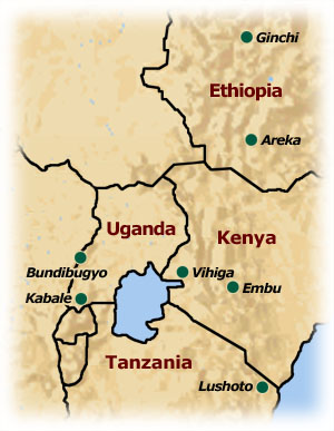
Primary Research Sites
Benchmark site selection is done based on both commonalities across sites (population density, apparent resource degradation, altitude) and the site's representativeness to larger highland regions in the countries in which they are located. This selection was done to enable cross-site comparison as well as enhance the extent to which approaches developed in one site can be extrapolated to others. In Phases I and II of AHI, from 1998 to 2002, eight benchmark sites were active in five countries. In Phase III, beginning in 2002, the number of the sites was reduced to five to concentrate efforts and to focus on specific but widespread NRM issues.
In Ethiopia, the benchmark sites are Areka, situated in the southwestern Ethiopian highlands at about 2000 masl and Ginchi, situated in the west-central highlands at 3000 masl. Areka is a very intensive enset/maize agricultural system, while Ginchi—conderably cooler than Areka, is ideal for the more extensive barley fallow system widespread throughout the highlands. In Kenya, the benchmark site is Vihiga, situated in the Lake Victoria basin with an altitude of approximately 1400 masl. This site has the highest population density (about 800 to 1200 people per km2), with subsequent effects of land shortage and high rates of migration to urban areas. In Tanzania, the AHI site is located in Lushoto, in the Usambara Mountains, at 1900 masl. This site is one of the more diversified cropping systems, with vegetable crops grown in the valley bottoms and staple crops and market-oriented perennials grown on the hillsides—where degradation is apparent. The Kabale site, located in the southwestern mountains in Uganda, ranges in altitude from 1500 to 2700 masl with an average rainfall of about 1000 mm per annum. Similar to Lushoto, livestock numbers are small and in decline due to population pressure and loss of grazing area and crop production predominates. All systems have trees integrated into the system, but tree biomass in Ginchi is the most limited overall due to the extensive grazing system and land tenure history.
A major agricultural concern in all of these sites is the overall deterioration of the resource base supporting agriculture and livelihoods, particularly water degradation (quality and quantity), removal of vegetative cover, decline in soil fertility and decline in overall system productivity. Major driving forces leading to unsustainable use of resources include historical factors (largely institutional and cultural), increased human population levels and the inadequacy of current-day agricultural development and natural resource governance systems. These drivers have contributed to continual expansion into marginal lands; increased competition for scarce water, grazing and forest resources; erosion of biodiversity assets; and limited investment in the maintenance of the natural resource base. Poor farmers, in particular, often rely more on the inherent quality of the resource base and can at least compensate for land degradation and the loss of wild sources of food, income, fuel and building supplies.
AHI's major NRM research frontiers have evolved over time from farm-level to landscape- and institutional-level interventions, but share a common emphasis on balancing income generation with equity and sustainability concerns. A few of the areas of research and intervention are highlighted below:
|
||||||||
 The African Highlands Initiative has been working in densely populated and intensively cultivated highlands in five eastern African countries: Ethiopia, Kenya, Tanzania, Uganda and Madagascar. About 36, 27, 17, 11% of Ethiopia, Madagascar, Uganda and Kenya are considered highlands, yet disproportionate numbers of people live in these areas. In Ethiopia and Kenya, about 81% and 64% of the population resides in these highlands, respectively.