An e-publication by the World Agroforestry Centre
INDIGENOUS KNOWLEDGE OF
MEDICINAL TREES AND SETTING PRIORITIES
FOR THEIR DOMESTICATION IN SHINYANGA REGION, TANZANIA

|
|
An e-publication by the World Agroforestry Centre |
|
INDIGENOUS KNOWLEDGE OF
MEDICINAL TREES AND SETTING PRIORITIES |
|
|
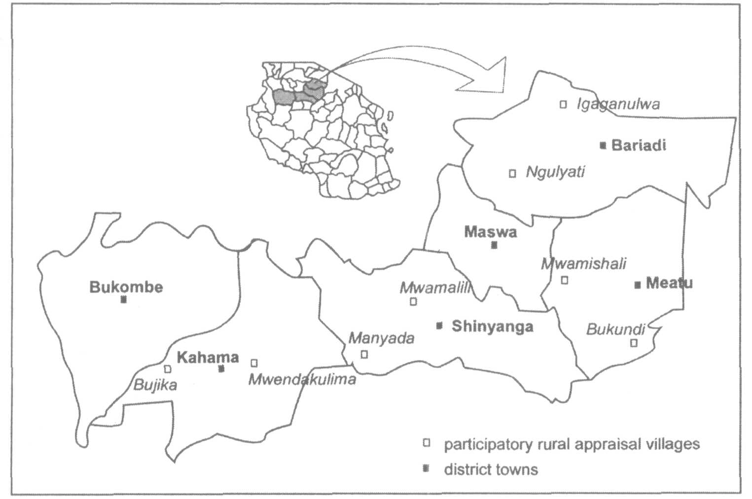
Chapter 2 General information on the study area Shinyanga Region lies south of Lake Victoria in the northwestern part of Tanzania. The region is situated between longitudes 31° and 35° east and latitudes 2° and 5° south. One of 20 administrative regions of mainland Tanzania, Shinyanga covers an area of 50 781 km2 and is the 9th largest region in the country. There are 6 administrative districts: Bariadi, Bukombe, Kahama, Maswa, Meatu and Shinyanga (fig. 2.1). The districts are subdivided into 27 divisions, 160 wards and 817 villages. Shinyanga is occupied mainly by the Wasukuma ethnic group. Other groups include Wanyamwezi, Wataturu, Wasumbwa, Wanyiramba and Wahadzabe. The region had a population of 1,763,960 during the 1988 census and is currently projected at 2 million, based on an annual average growth rate of 2.9%. Population density varies from 18 persons km-2 in Meatu District to 183 persons km-2 in Shinyanga Urban District with an average of 35 persons km-2 (Kileo and others 1995).
The annual rainfall in the region varies from about 600 to 900 mm, with a mean of 700 mm; the rainy season begins in November and ends in April-May. Rainfall is erratic and poorly distributed with high variability within and between seasons. The rainy season is characterized by short dry spells, which are often detrimental to crop production. Monthly temperatures vary between 27.6°C and 30.2° C maximum and 15°C to 18.3º minimum (Kileo and others 1995).
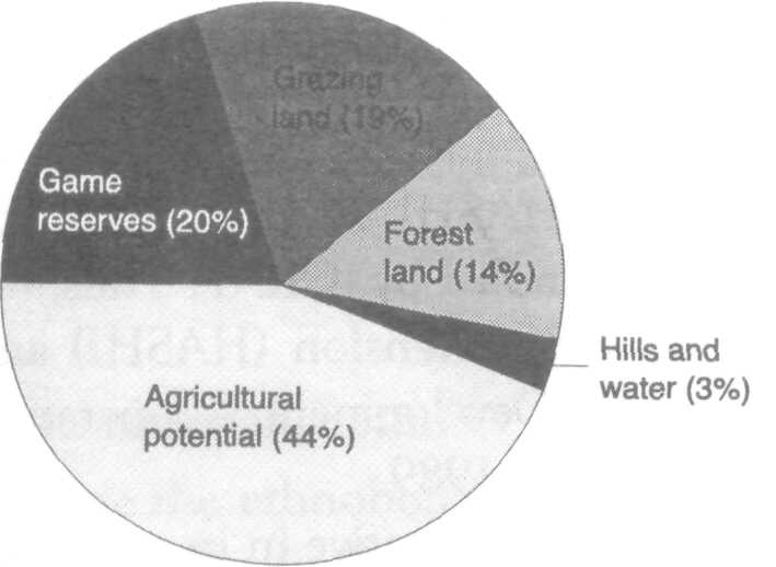
The region is characterized by flat, gently undulating plains interspersed with low ridges, hill blocks and ranges. The general altitude varies from 1000 m in the southeast to 1500 m in the northeast. Soils are mainly clayish but vary tremendously from hilltops to valley bottoms. On hilltops, soils are moderately well drained, greyish brown and sandy (ferric Acrisols and Oxisols). Moderately deep, well-drained, greyish brown sandy loam soils (ferric Luvisols) occur on the slopes (Hathout 1972). On the low-lying bottomlands are the poorly drained black clays (Cambisols and Vertisols). Vertic soils are quite extensive, covering about 47% of all soil types in the region. These are relatively fertile but susceptible to flooding for at least 2 months during the rainy season. Shiyanga Region was extensively forested with woodland and bushland species such as Acacia, Albizia, Brachystegia, Commiphora and Dalbergia (Otsyina 1992). However, during the 1920s and 1930s, large areas of land were cleared of bush and trees as part of eradication programmes for tsetse fly and quelea bird. Since then, deforestation and bush clearing have continued to the extent that the forest area today is but a small part of the land surface (fig. 2.2). Currently, much of the cultivated area in the region contains sparsely distributed Acacia species and Adansonia digitata (baobab) trees. Land use and agriculture The potential agricultural land in Shiyanga is estimated at 2 193 500 ha, but the area used for annual crop production scarcely exceeds 10% (fig. 2.2). As mentioned earlier, the Sukuma people, who are sedentary agro-pastoralists, predominate in the region. Although they are basically cultivators, keeping livestock is important for them for both economic and cultural reasons (Brandstrom 1985). The livestock component provides milk and animal products for household consumption, ox ploughing and transportation. In addition, animals fulfil various social functions and act as a bank or security for individual families. Major crops grown in the region include millet and sorghum on the sandy clay soils, cassava, cotton and maize on the fine sandy soils on the mid-slopes and rice on the clay soils. Cotton, the major cash crop, is grown in monoculture. Maize, sorghum and millet are grown in mixtures with food legumes. Rice production is becoming increasingly important.
The depletion of natural resources and soil cover has led to the following adverse impacts on the socioeconomic development in the region:
The HASHI/ICRAF Project Land degradation in Shinyanga was the main issue during the conference 'Environmental Conservation through Tree Growing' held in 1984 at the Mwadui diamond mining complex near Shinyanga. Among the participants was the then president of Tanzania, Julius Nyerere. As a follow-up to one of the resolutions of that conference, a project to improve and protect the environment of Shinyanga from further degradation was initiated in 1986. It was named Hifadhi Ardhi Shinyanga or HASHI. As from 1991, the research component of this project has been handled by 1CRAF. Thus, the project has become a unique marriage between extension (HASHI) and research (ICRAF). The Norwegian Agency for Development Cooperation (NORAD) has been its main source of funds since 1989. The HASHI/ICRAF Project has so far proven innovative in its approach to improving land use in Shinyanga through local participation. In addition to developing and disseminating agroforestry technologies, it has been quite successful in creating awareness of tree planting and other environmental issues in the region (HASHI/ICRAF 1998). In line with its motto of going to the people and building on what they know, the project places great emphasis on indigenous knowledge and has adopted some of the Sukuma nature conservation methods such as grazing reserves (ngitiri). Tree-planting programmes have also been initiated through various government and non-government projects to improve tree cover and provide people and communities with needed wood products.
Health services in the region are provided by the government, the private sector, religious institutions, traditional healers and birth attendants. The government is the main health service deliverer with a regional hospital in Shinyanga Urban and 5 district hospitals. The government also runs over 257 dispensaries and 14 health centres in the region (Kileo and others 1995). Despite the increasing efforts of government and the private sector to meet health care needs, the health facilities in the region are woefully inadequate. The health situation in the region is still characterized by a high death toll from preventable diseases such as malaria and waterborne diseases, and high rates of infant mortality. Available data also show that there are 78 704 people for every qualified medical doctor in the region. The universal dream of 'health for all by the year 2000' will certainly elude the people of Shinyanga unless present efforts are doubled in the next couple of years. As revealed in this study, the role of traditional healing can never be overemphasized in the pursuance of health for all in the region. |