![]()
An e-publication by the World Agroforestry Centre
METEOROLOGY AND AGROFORESTRY

|
|
An e-publication by the World Agroforestry Centre |
|
METEOROLOGY AND AGROFORESTRY |
|
|
section 7 : windbreaks Wind reduction and soil water availability near a 'Caatinga shelterbelt P.C.E. Frota, A.D. Ramos and E. Carrari
Agricultural Research Agency of Ceara (EPACE)
Abstract This research was done in the Experimental Farm of Research Unity of Central Country Ceara (EPACE), in the semi-arid region Northeastern Brazil, at 200m altitude and geographic coordinates 4°50'S and 39° W. It used a belt of natural caatinga, with mean height of 4m and 20 m width, remaining after clearing of the area to get improved pasture for goats. Measurements of wind speed, evaporation and soil water content were done using the proper equipment set at the following distances after the windbreak: 4,8 and 16m. Wind speed decrease was measured in the range of 77 to 94% and evaporation reduction had a variation from 0,5 to 2,4m.
The state of Ceara, in the semi-arid region of Brazil, presents strong water deficit characteristics in most of its territory and during considerable time periods (Hargreaves 1974; Golfari 1977). The vegetation is mostly poor in wood-producing species. The small water volume held in the soil is subject to high losses due to evapotranspiration. On the other hand, evapotranspiration depends greatly on solar radiation intensity, temperature, photoperiod, atmospheric moisture and winds (Mota 1975), which are related to edaphic factors and vegetative cover. Control of wind speed by shelterbelts creates a microclimate that may reduce the water deficit, increasing the duration of water availability in the soil, and thus protect the soil against erosion and removal of litter from the rows between the trees. Shelter-belts have played an important role in temperate and tropical countries giving protection to the crops and increasing productivity (FAO 1981). Intensive investigations of shelterbelt influence on productivity have been made in regions where eolic action causes damage to crops. In Bulgaria, protection by a shelter-belt of Robinia pseudocacia 2 meters broad and 9 meters high increased volumetric production of sugar cane 32% and sugar content 1% (Dzhodzhov and Georgiev 1980). A pasture system with a central bosquet and shelterbelts of trees on the borders gave an increase of 20% in goat productivity (Wilson 1980). The Ukraine had in 1980 over 416,000 hectares of shelterbelts giving protection to 4 million hectares of crops, resulting in increased agricultural productivity on the collective farms, as well as producing forest products (Dmitrenko 1981). Tribunskaia and Shcherbakova (1978) concluded that shelterbelts in semi-desert regions of north Caucaso-Russia saved 100 million rubles per year in agricultural product. Bodrov (1978) stated that those systems can offer extra income in arid zones by causing higher water retention in the soil, and so increasing agricultural productivity. In Brazil, there have been few studies that evaluated the potential of these techniques. Most species recommended in the literature for creating shelterbelts in arid and semi-arid regions have not been tested in Brazil. Recent results have shown that some experiments with Eucalyptus excerta, E. alba, E. camaldulensis and E. crebra are promising for use in arid climates (Pires and Ferreira 1982).
We present here partial data of a research project that aims to determine the efficiency of natural caatinga vegetation used as a shelterbelt. The experimental site is in Quixad, Ceara, (05° S; 39° W; 200 m asl), a semi-arid region of north-eastern Brazil. Mean annual rainfall is 700 mm with rains during summer and autumn and a distinct dry season of 7 to 8 months. Soils were classified as non-calcic brown soils, with an ochric A horizon, clay texture, and rolling topography with 3 to 6% slopes. A caatinga natural belt with mean height (H) of 4 m and width of 20 m remained after clearing an area for an improved goat pasture. Three sets of instruments were placed at 4, 8 and 16 m (1H, 2H and 4H) from the windward and leeward sides of the belt. Wind speed was measured at 1.5 m height; evaporation was measured by a USWB Class A pan; and soil moisture content was found by gravimetric sampling from three depths: 0.10,0.30 and 0.50 m.
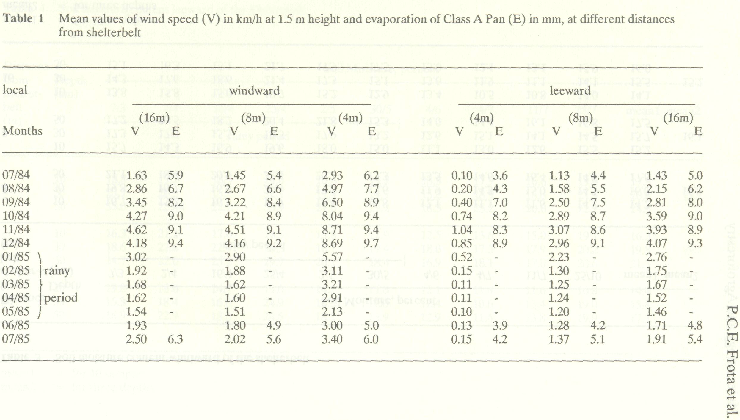
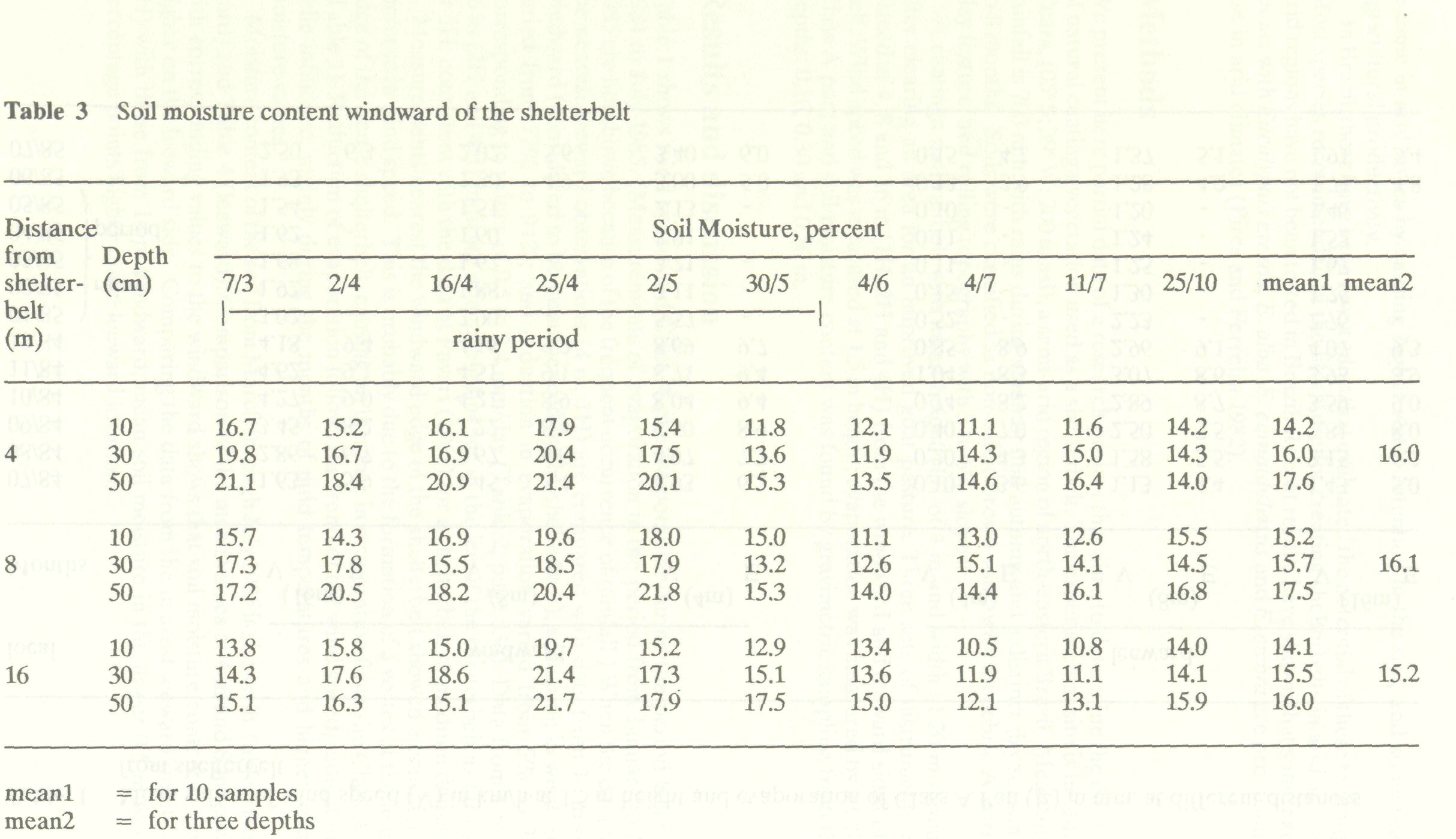
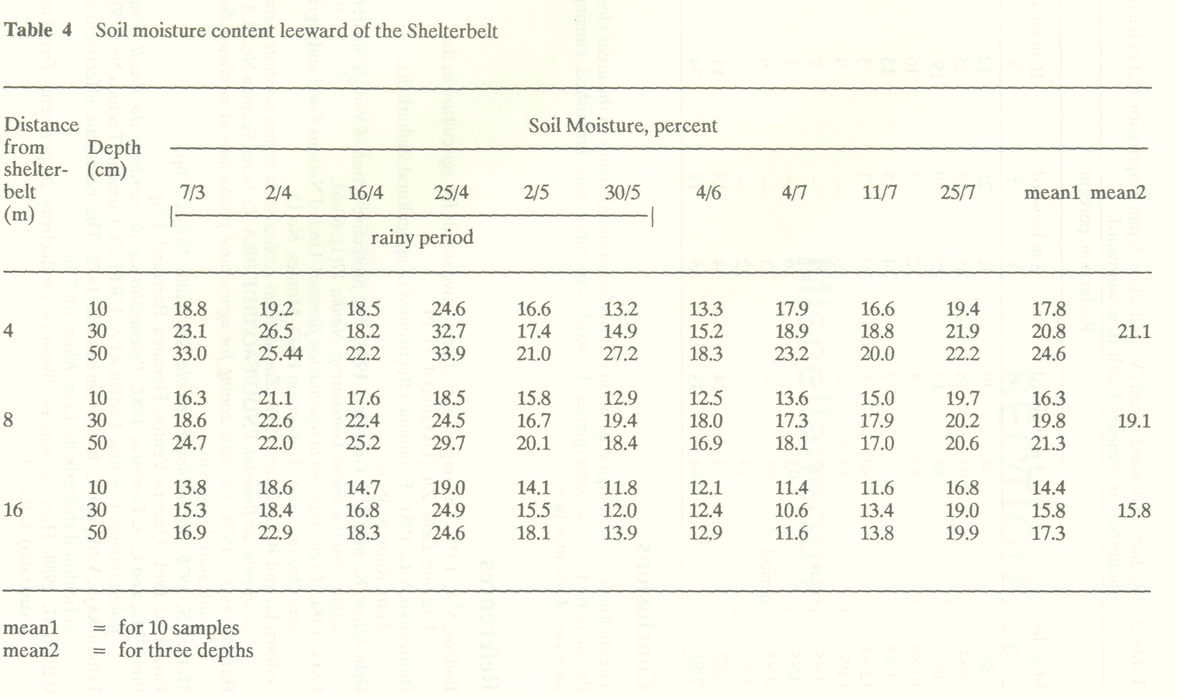
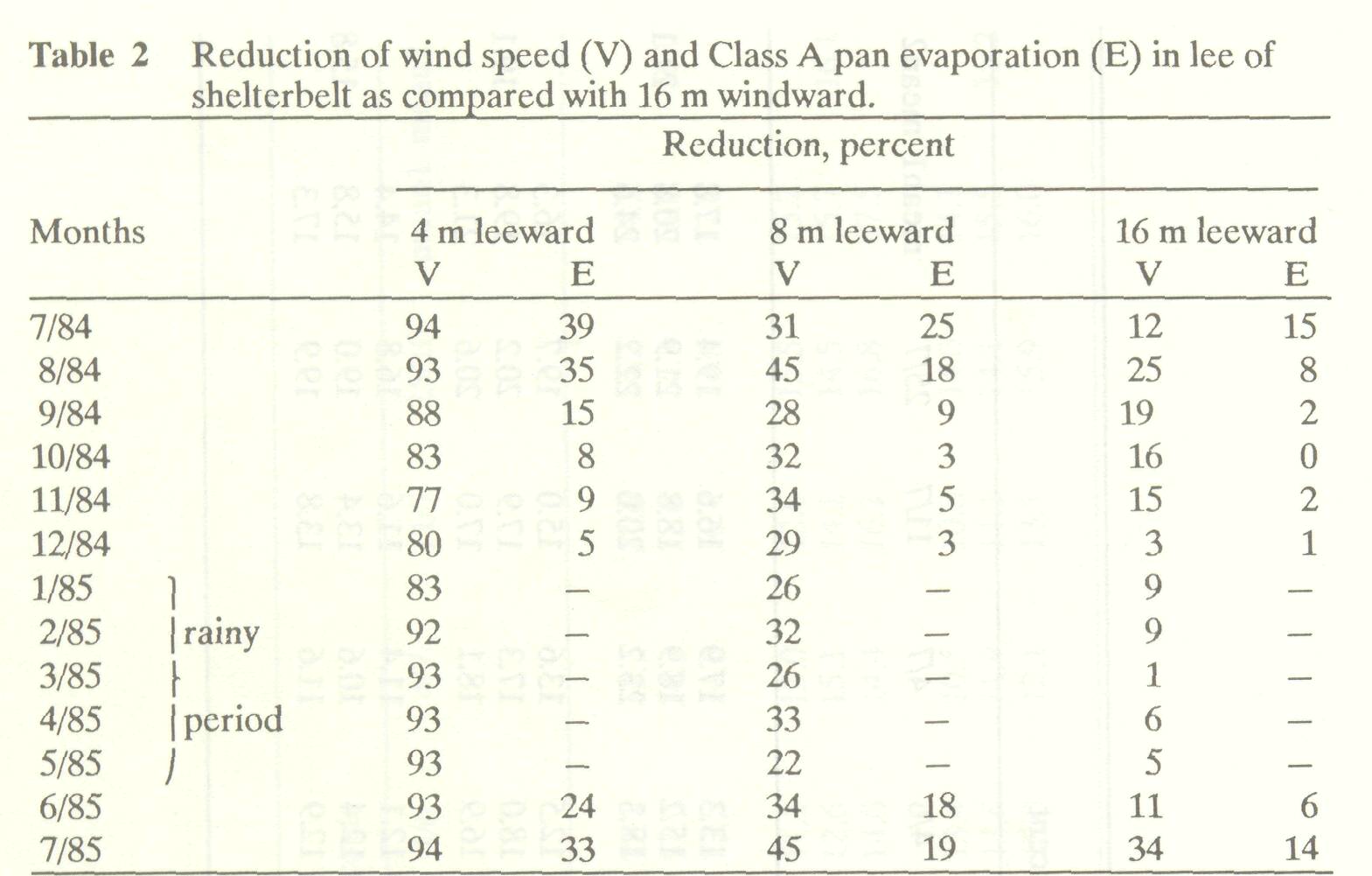
Table 1 shows wind speed and Class A pan evaporation during the period from July 1984 to July 1985. (Measurements of evaporation in the period from January to May 1985 are not shown because of the frequent occurrence of rainfall.) When the data from the nearest leeward observations (4 m, 1H) are compared with data from 16 m (4H) windward (considered to be uninfluenced by the shelterbelt), reduction in wind speed varied from 77% to 94%; and reduction in evaporation varied from 5% to 39%, corresponding to values of 0.5 to 2.4 mm/day (Table 2, page 536). Data from 8 m and 16 m (2H and 4H) indicate effective influence in the lee of the shelterbelt as far as 4H or 5H, consistent with the data of Pavari (1961) for a shelterbelt of medium density. Measurements nearest the windward edge of the shelterbelt showed a considerable increase in wind speed. This is probably due to the formation of a vortex at the leading edge of the dense shelterbelt, causing an increase in evaporation from the Class A pan (Table 1). Reduction of evaporation follows the trend of the wind speed, indicating an eolic influence, mainly during the months of mild temperatures and higher relative moisture values. Moisture content of the soil from March through July 1985 is shown in Table 3 (windward) and Table 4 (leeward). Comparison of the mean values at 4 m and 8 m leeward with corresponding values to the windward shows that soil moisture content is always higher on the leeward side. Comparing the data from the nearest leeward point (4 m, 1H) with those from 16 m windward, mean soil moisture in the upper 0.5 m was 5.9 percentage points higher in the leeward location.
Conclusions The shelterbelt of caatinga vegetation reduced wind speed mainly in the areas close to the shelterbelt. As a consequence, leeward evaporation was diminished, causing an increase of soil moisture.
Bodrov, V.A. 1978. The importance of protective stands for agriculture in the Ukraine. Lesn. Zh. (Ukrania) 4:11-19. Dmitrenko, V.L. 1981. Economic effectiveness of agricultural shelterbelts. Lesn. Khoz. 8: 38-40. Dzhodzhov, K., and G. S. Georgiev. 1980. The protective action of a single shelterbelt against wind erosion. Gorskostop. Nauka 17(1): 60-64. FAO. 1981. El eleucalipto en la repoblacion florestal. United Nations Food and Agriculture Organization. Colleccion FAO, Montes. No.ll. Golfari, L., and R. L. Caser. 1971. Zoneamento ecologico da regiao nordeste para ex perimentacao florestal. PNDU/FAO/IBDF/BRA-45. Serie Tecnica No.10.115p. Hargreaves, G. 1974. Climatic zoning for agricultural production in northeast Brazil. Utah State University. Mota, F.S. 1975. Meteorologia agricola. Sao Paulo: Nobel. 376p. Pavari, A. 1961. Quebra-Ventos. Floranca: Bertrand. 179p. Pires, I.E., and C. A. Ferreira. 1982. Potencialidade do nordeste do Brasil para re- florestamento. Curitiba, EMBRAPA, URPFCS, Circular Tecnica No.6. 30p. Tribunskaya, V.M., and L. B. Schcherbakova. 1978. The economic effectiveness of agricultural shelterbelts. Lesn. Khoz. 10: 7-10. Wilson, G. 1980. How to increase livestock productivity 20 per cent. Tree Farmer (Australia) 3:107-11. |