![]()
An e-publication by the World Agroforestry Centre
METEOROLOGY AND AGROFORESTRY

|
|
An e-publication by the World Agroforestry Centre |
|
METEOROLOGY AND AGROFORESTRY |
|
|
section 3 : Regional examples The need for meteorological information to plan agroforestry on steep slopes in Ethiopia M. Negash
Land Use Planning Department, Ministry of Agriculture Abstract Ethiopia is characterized by land features of mountains, hills, plateaus, valleys and gorges. In general, the land above 1500 m elevation is classified as highlands. The country covers 124 million hectares of land comprising 42 million people. Agriculture is the dominant sector of the economy. It contributes to 90% of the exports and an employment of more than 80% of the labour force. On the other hand, 95% of the cultivated lands are situated in the highlands where 88% of the human population and two thirds of the livestock are found. The highlands are rugged and steep. As a result of their steepness, overgrazing, overcultivation and wanton deforestation, the highlands suffer from environmental degradation. The traditional climatic zones prevailing in the country are:
In these zones, 12 major land use and cover types were identified from satellite imagery interpretation and limited field checks. The cropland occupies 14.8%; grazing and browsing land 51%; forests 3.6%; and currently unutilizable land 18.7%; of the country. In the history of Ethiopian agricultural land use, agroforestry is closely related to intercropping of perennial and annual crops. It is widely practiced in the south, southwestern and eastern parts of the country. Agroforestry has also recently been recognized as impoerant soil and moisture conservation. At present, the productivity of the highlands is declining below the food requirements of the people and the livestock. The reasons are severe soil erosion and decline in the fertility of the soils resulting from poor land management practices. In order to reverse the situation, scientifically designed and planned agroforestry farming systems are urgently needed on steep slopes. The systems should itegrate resource -conservation - based production of crops, livestock, woods and conservation of nature. However, these require basic information on climate, soils and slope classes. In Ethiopia, 6 rainfall pattern regions, 10 thermal zones, 15 length-of-growing periods, 18 major soil types, 380 land systems and 5 slope classes were identified at exploratory levels of studies.
Ethiopia is situated between 3° and 18° north latitude and 48° east longitude (i.e., in East Africa). It is mainly characterized by land features of mountains, hills, plateaux, valleys and gorges. In general, the land above 1500 m asl is considered rugged highlands. The country has a total land area of about 124 million hectares and comprises 42 million people (FAO 1986a). Agriculture is the dominant sector of the economy. It contributes to 90% of the exports and an employment of 88% of the labour force. The farm families organized into peasant association are about seven million and the annual population growth is about 2.9% according to the 1984 national census. Ninety-five per cent of the cultivated lands are in the highlands. They contain 88% of the country's human population, two-thirds of its livestock and over 90% of its economic activity. However, the highlands suffer from environmental degradation as a result of overgrazing, overcultivation, excessive deforestation, and slashing-and-burning of the natural vegetation cover. The destruction of forests according to recent estimates is 200,000 ha per year which is over the potential capability of the existing 3.6% forest land. The sensitive arid and semi-arid vegetation of the lowlands is badly threatened by overgrazing. The present estimate of the annual country-wide soil loss rate is 2 billion cubic meters. The highlands are seriously threatened by sheet, rill and gully erosion. Sheet and rill erosion attack mainly cultivated lands and grazing lands. For these reasons, the fertility and productivity of the highlands is declining rapidly.
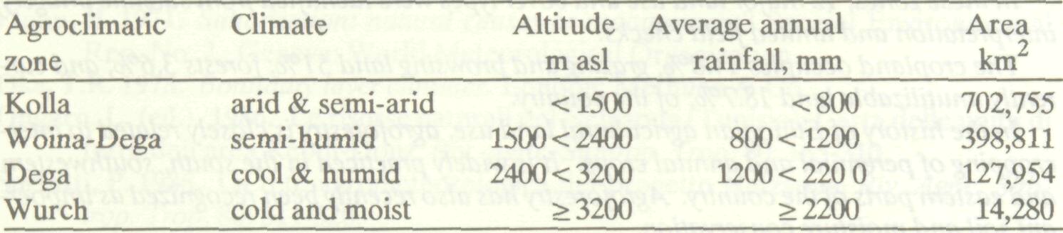
The four traditional agroclimatic zones of Ethiopia are distinguished by the linked factors of altitude, annual rainfall and temperature (Table 1). Table 1 Traditional agroclimatic zones.
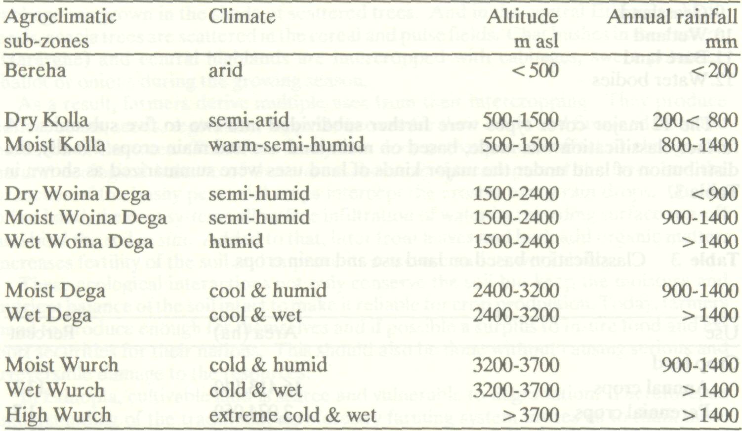
However, rainfall is related to geographical position as well as altitude. At a given, altitude, a site in Tigre or Eritrea, or in the south-eastern region towards the frontiers of Somalia or Kenya, is likely to receive less than a site in Shewa, Keffa, Elubabor or Wellega. In order to understand in detail the agroclimatic conditions of the country, the four agroclimatic zones are sub-divided into 11 sub- agroclimatic zones based upon the distributions of the average annual total of rainfall (Table 2). Table 2 Sub-division of agroclimatic zones.
The five slope classes distinguished in Ethiopia are: 0-10%, 11- 25%, 26-35%, 36-50% and more than 50%. Slope class 0-10% occupies mainly the lowlands below 1500 m elevation (about 703,000 km2 ) and the flat highland plateau and valley bottoms. The other classes are found mainly in the highlands. Slopes greater than 50% occupy a large area compared to the other classes.
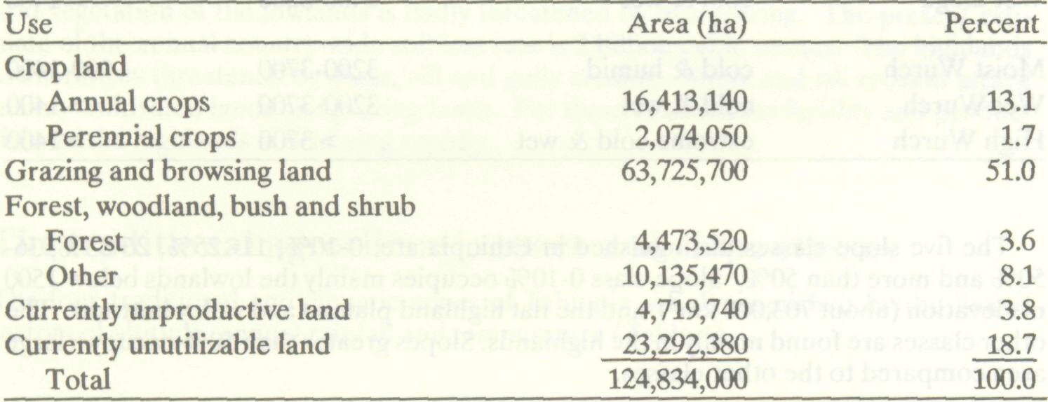
Land use refers to the uses to which the land resources are put by man to derive the maximum benefits in order to satisfy his social and human needs. These are food, clothing, shelter, firewood and other materials such as wood for furniture (FAO 1986b). Land use involves the physical interaction between the resources and the powers of man and animal required to produce the necessary commodities. However, land cover types reflect only the natural and physical features of the resources from which man can benefit. These resources are vegetation, soils, water, cultivated land areas, salt flats and the rocks. Vegetation by itself comprises forests, woods, bushes, shrubs and grass at various levels of cover density. In Ethiopia, a land-use/land-cover study was carried out by interpretation of Landsat imagery (1972-1979) and limited field checks (FAO 1984a). The study distinguished 12 major land cover types:
The 12 major cover types were further subdivided into two to five sub-units. A further classification was made, based on main land use and main crops. Finally, the distribution of land under the major kinds of land uses were summarized as shown in Table3. Table 3 Classification based on land use and main crops.
In the history of Ethiopian agriculture, intercropping is a common practice especially in the south, south-western and eastern parts of the highlands. At present, it is remarkably considered as an old agroforestry practice in the perennial crop growing areas. Among the perennial crops, coffee, ensete and chat (Chata edulis) could be mentioned as common examples. The history of the traditional agroforestry farming systems in Ethiopia goes back to the beginning of coffee production in the country. In general, coffee grows wild as well as cultivated in the south and south-western highlands. However, it is cultivated in pure stands in the eastern and central highlands. Wild coffee grows naturally as bushy strata under tall forest trees, while cultivated coffee is common to homesteads under the shade of irregularly scattered trees. The common shade tree genera are Albizia, Acacia and Corida. All of these have flat and wide umbrella-shaped canopies. However, the canopies allow an optimum amount of light rays to penetrate and reach the coffee bushes. On the other hand, since the shade trees and the coffee bushes are scattered, there is enough space to plant other crops in between. Farmers in the south till the coffee fields in the rainy season with hoes and intercrop them either with cereals such as maize and sorghum; pulses; or root crops such as taro, potatoes and cassava. Some farmers intercrop coffee with perennial crops such as ensete, lemons, oranges, limes and hops. In some other perennial crop areas, where coffee is not commonly grown, ensete and cabbage are grown in the shade of scattered trees. And in the central Ethiopian highlands, acacia trees are scattered in the cereal and pulse fields. Chat bushes in the eastern (Hararghe) and central highlands are intercropped with cabbages, sweet potatoes, shallot or onions during the growing season. As a result, farmers derive multiple uses from their intercropping. They produce coffee, beans, seeds, vegetables, loppable browse for their cattle and firewood from the branches of the trees. Therefore the system does not very much affect or change the natural ecological balance of these areas, because the canopies of the trees and the branches of the bushy perennial crops intercept the erosive heavy rain drops. On the other hand, the root systems allow free infiltration of water by retarding surface run-off and bind the soil in situ. Added to that, Utter from leaves and bark add organic matter, increases fertility of the soil and improve its structure and its workability. These ecological interactions not only conserve the soil but keep the moisture and nutrient balance of the soil intact to make it reliable for crop production. Today, farmers need to produce enough for themselves and if possible a surplus to insure food and export securities for their nations. This should also be done without causing serious and irreversible damage to the resources. In Ethiopia, cultivable land is scarce and vulnerable to degradation. Therefore, an understanding of the traditional agroforestry farming system invites us to think more scientifically about its advantages and to design scientifically-tested systems to protect our environment. This requires identification of the quality and distribution of various environments, the crops to be grown, their optimum environmental requirements, and the trees and shrubs to be integrated within the system. It also involves the selection and breeding techniques of high yielding plant and/or crop species, proper management and conservation techniques and designs. However, identification of techniques should rely upon research findings and recommendations in order to arrive at conservation-based multiple productivity of the resources.
For many centuries subsistence mixed agriculture has been practiced, mainly in the highlands of Ethiopia. It integrates both livestock- rearing and the production of rainfed cereals, pulses, perennial crops, fibre crops and oil crops. Oxen and man were and still are the main sources of farm power. Cows are reared to produce oxen and some milk products. Goats and sheep are kept mainly for meat and as a source of cash in the peasant economy. Horses fulfil the need for transportation of humans and goods. However, for many centuries, land has been ploughed and grazed without thinking of soil and water conservation measures. As a result of human and livestock pressure on the land, cultivated and grazing lands are expanding at the expense of the natural vegetation. Therefore, erosion in the highlands is aggravated as a result of misuse of land and wanton destruction of the natural vegetation. Drought is a common and recurrent phenomenon, especially in the north and north-eastern parts of the country. The environment of the Ethiopian highland is fragile because of its rugged and steep terrains. It requires wise and scientific uses for its sustained productivity. For instance, if one compares the north with the south and south-western regions of the highlands, the latter are better protected than the former because of considerable cover by vegetation and old practices of agroforestry-oriented farming. In the south and south-western regions, perennial crops (e.g., ensete and coffee) and their associated tree canopies intercept the rainfall thereby protecting the soil from its erosive power. On the other hand, soils in the northern, north-eastern and central highlands are heavily washed and the environment is degraded. Crop failures and significant yield decreases are common phenomena in these areas. The causes are serious droughts and bareness of the ground. Therefore, people and livestock are suffering from shortages of food and feed in those areas. In order to reverse the degradation of the environment and halt the ongoing soil loss, scientifically-based agroforestry systems planning is badly needed on the steep highlands of Ethiopia. In such a system, the major concern of planning should be efficient soil- and water-conservation practices and sustained production of cereals, pulses, oil crops, fruit, fodder (browse and herbs), firewood and wood products.
In Ethiopia there are more than 506 climatic stations. All operate under the authorization of the National Meteorological Service Agency (NMSA), which is responsible for the collection, analysis and distribution of the climatic data. Of these, 213 record precipitation; 192 stations record precipitation and temperature; 52 stations precipitation, temperature and relative humidity; four stations precipitation, temperature, relative humidity and solar radiation; 18 stations precipitation, temperature relative humidity, solar radiation, and sunshine duration; 27 stations precipitation, temperature, relative humidity, solar radiation, sunshine duration and wind-speed. Many of the stations have records of more than 5 years. However, only a few stations, such as Gore and Addis Ababa, have records of more than 35 years. The shortcomings of the climatic data in Ethiopia are the short periods of observations; the poor quality of the data due to inconsistency of records; and the relatively few stations that make comprehensive agroclimatic measurements.
The Land Use Planning and Regulatory Department (LUPRD) of the Ministry of Agriculture studied the climatic patterns of Ethiopia sources (FAO 1984b). Six major rainfall pattern regions were distinguished. Rainfall pattern region 'A' encompases the north-eastern and south-western parts of the country. The region receives rain in summer (i.e., in June, July, August and September). In the highland areas, precipitation exceeds one-half potential evapo-transpiration (PET) at the beginning and end of the rainy season; and full PET in the middle of the rainy period. However, in the lowlands of north-eastern areas the rainfall exceeds ½ PET only in July and August and is always below full PET. Therefore, the lowland areas suffer from shortage and insufficiency of rains. Region 'B' encompasses the southern and south-western parts of the country. The region receives tremendous amounts of precipitation from March to early December in highland areas; and from mid-April to November in the lowland humid savanna areas. Precipitation always exceeds full PET for most of the rainy season. The region is characterized by rains occurring from spring to autumn and is ecologically stable with vigorous vegetation growth and cultivated perennial crops such as coffee, ensete and rootcrops. Region 'C' receives rain in spring, summer and autumn. The region covers the eastern and south-eastern plateaux and escarpments. The rainfall occurs from February to November in highland areas and from March to November in the low-lying areas. In most of the regions, precipitation during the rainy season is more than ½ PET. Except for some low-lying areas, the region does not suffer from an insufficiency of moisture for the growth of natural vegetation. Region 'D' covers the north-eastern Red Sea coastal areas. It enjoys rains throughout the year. However, summer rain is small compared with the other three seasons. In most of the areas, precipitation is below ½ PET. Therefore, growth of natural vegetation is highly affected by the short and zero length of the growing period. Therefore, the region is considered not climatically suitable for cultivation of crops and livestock rearing. Region 'E' covers the whole of the Ethiopian rift valley and the eastern, central and south-eastern highlands. It receives rains from March to the beginning of October i.e. small rains in spring and big rains in summer merging together. However, there prevails a very short dry spell in May which has little effect on crops and the growth of natural vegetation. In most of the highland areas precipitation is higher than potential evapotranspiration. But in the lowlands, like in 'Dire Dawa', precipitation is always between half and full PET. Region 'F' covers the southern and south-eastern frontiers with Kenya and Somalia. It has a bi-modal rainfall distribution, with spring rainfall considerably greater than the autumn rainfall. The significant rainy months are April to the end of May and from September to November. The rains bordering region 'C' of this zone are more reliable than rains in the south-west and south-east. In the highland areas near region 'C', precipitation is less than ½ PET. In the region no major rain-fed crops are grown and the natural vegetation is dominated by thorny low shrubs.
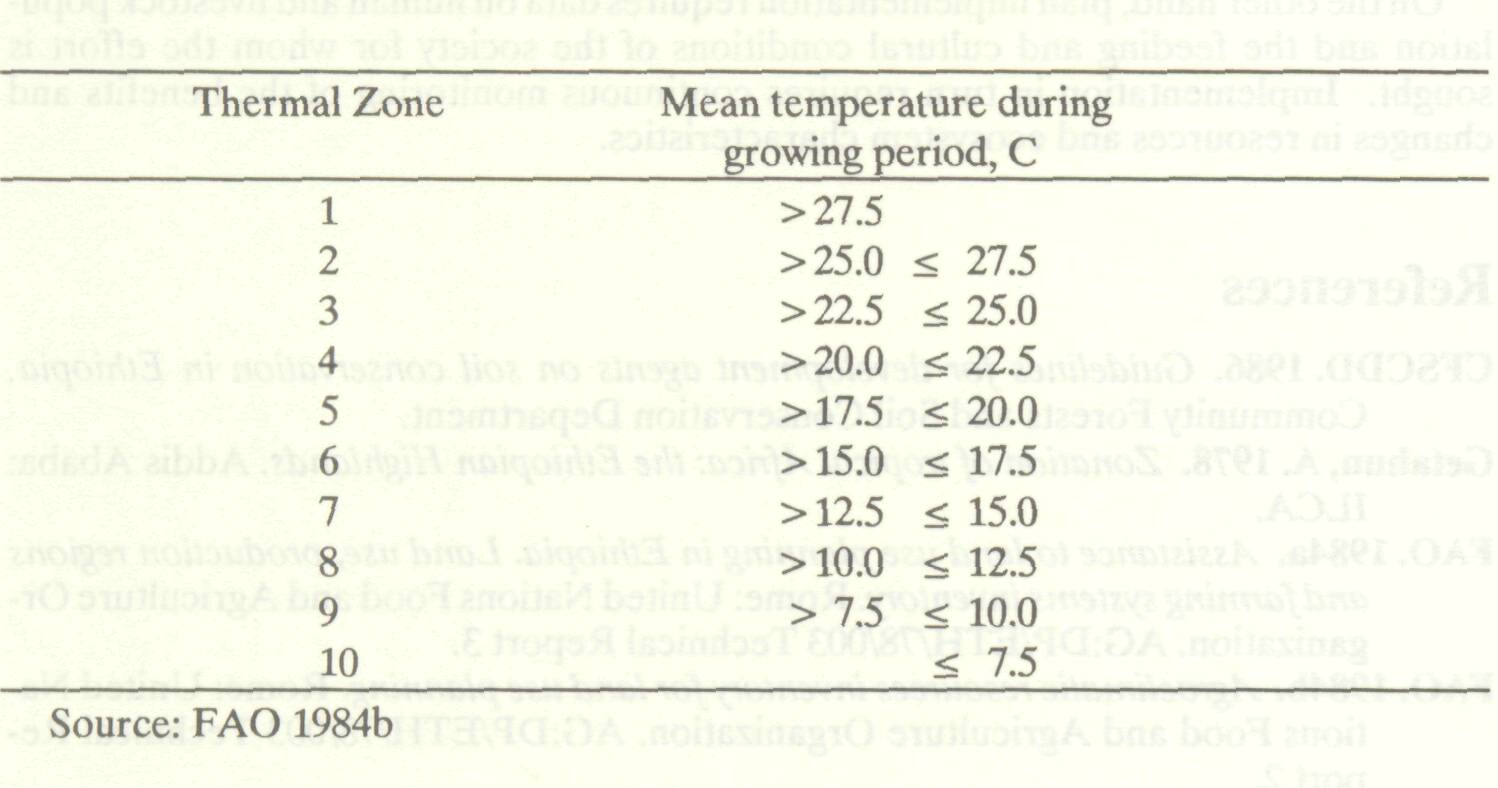
In Ethiopia, average temperature decreases about 0.6 °C for every 100 m increase in elevation. In this regard, the temperature gradient determines the distribution of annual and perennial crops, livestock and the natural vegetation in general. The LUPRD (FAO 1984b) distinguished 10 thermal zones based upon mean temperature during the growing periods (Table 4). Table 4 Thermal zones.
The zones help determine the types of crops, trees, shrubs and herbs to be found and grown, produced and reserved in a certain locality.
Length of growing period is determined by the interrelated analysis of precipitation, soil moisture holding capacity, potential evapotranspiration and frost period. The growing period is considered to begin when precipitation exceeds ½ PET and end when precipitation falls below ½ PET. Length-of-growing period 0 to 90 days occurs in the north- eastern, eastern, southeastern and southern lowlands. There the natural vegetation is very scanty and consists primarily of thorny- bush acacias. The highlands and the north-western, western, and south-western lowlands are characterized by growing periods longer than 90 days.
Mapped information on the physical environment (at scale of 1:1,000:000) is available from LUPRD. Since soils are the vital medium for plants growth, their nature, and characteristics should be known to help in planning, decision making and implementation. In Ethiopia 18 dominant soil types, 380 landscape units and 120 soil management units have been identified and characterized. This information enables planners and decision makers to identify the relevant types of agroforestry based developments to be undertaken in the areas where they should be necessary.
Agroforestry planning requires scientific decisions on an integration of resource-conservation-based multiple use systems. Multiple use can be interpreted as integration of pulses, cereals, fruits and firewood production; or integration of wood and fodder production; or integration of fruits, recreation and nature conservation. However, choices of species and varieties should rely upon the available natural resource information. On the other hand, plan implementation requires data on human and livestock population and the feeding and cultural conditions of the society for whom the effort is sought. Implementation in turn requires continuous monitoring of the benefits and changes in resources and ecosystem characteristics.
CFSCDD. 1986. Guidelines for development agents on soil conservation in Ethiopia. Community Forests and Soil Conservation Department. Getahun, A. 1978. Zonation of tropical Africa: the Ethiopian Highlands. Addis Ababa: ILCA. FAO. 1984a. Assistance to land use planning in Ethiopia. Land use, production regions and farming systems inventory. Rome: United Nations Food and Agriculture Organization. AG:DP/ETH/78/003 Technical Report 3. FAO. 1984b. Agroclimatic resources inventory for land use planning. Rome: United Nations Food and Agriculture Organization. AG:DP/ETH/78/003 Technical Report 2. FAO. 1984c. Assistance to land use planning in Ethiopia. A land resources inventory for land use planning. Rome: United Nations Food and Agriculture Organization. AG:DP/ETH/78/003 Technical Report 1. FAO. 1986a. Ethiopian highlands reclamation study. Rome: United Nations Food and Agriculture Organization. AG:UTF/ETH/037. Final Report, Vol. 1. FAO. 1986b. Assistance to land use planning in Ethiopia. An inventory of climate, vegetation and land use in Bichena (Gojam). Addis Ababa: United Nations Food and Agriculture Organization. AG:DP/ETH/82/010. Field document 12. Negash, M. 1986. Agro-ecological basis for the location of research centres and experimental sites in Ethiopia. Addis Ababa: Ministry of Agriculture, LUPRD. Unpublished paper. Westphal, E. 1975. Agricultural systems in Ethiopia. Wageningen: Centre for Agricultural Publishing and Documentation. |