![]()
An e-publication by the World Agroforestry Centre
METEOROLOGY AND AGROFORESTRY

|
|
An e-publication by the World Agroforestry Centre |
|
METEOROLOGY AND AGROFORESTRY |
|
|
section 3 : regional example The continental oases of southern Tunisia and the agrometeorological network of the Nefzaoua Project P. Sarfatti and L. Ongaro
Istituto Agronomico per I'Oltremare Abstract The Nefzaoua Region represents the final phase in the transition from the mediterranean climate to the warm desert climate. We examine the 'agrometeorological efficiency' of the traditional oasis system and illustrate certain trends in oasis management. Finally we describe the agrometeorological network of the Nefzaoua Project.
The Nefzaoua Project managed by the Istituto Agronomico per l'Oltremare of Florence (IAO) and the Institut des Regions Arides of Medenine (IRA), is a cooperative project between Italy and Tunisia. Its aim is to combat desertification and to improve the traditional management of the oasis. Though agroforestry has been developed in the humid tropics with completely different plants, nevertheless its principles and techniques might also help to deal with efficient use of light and water in complex multi-strata vegetation structures in arid climates, such as the continental oases of the Nefzaoua.
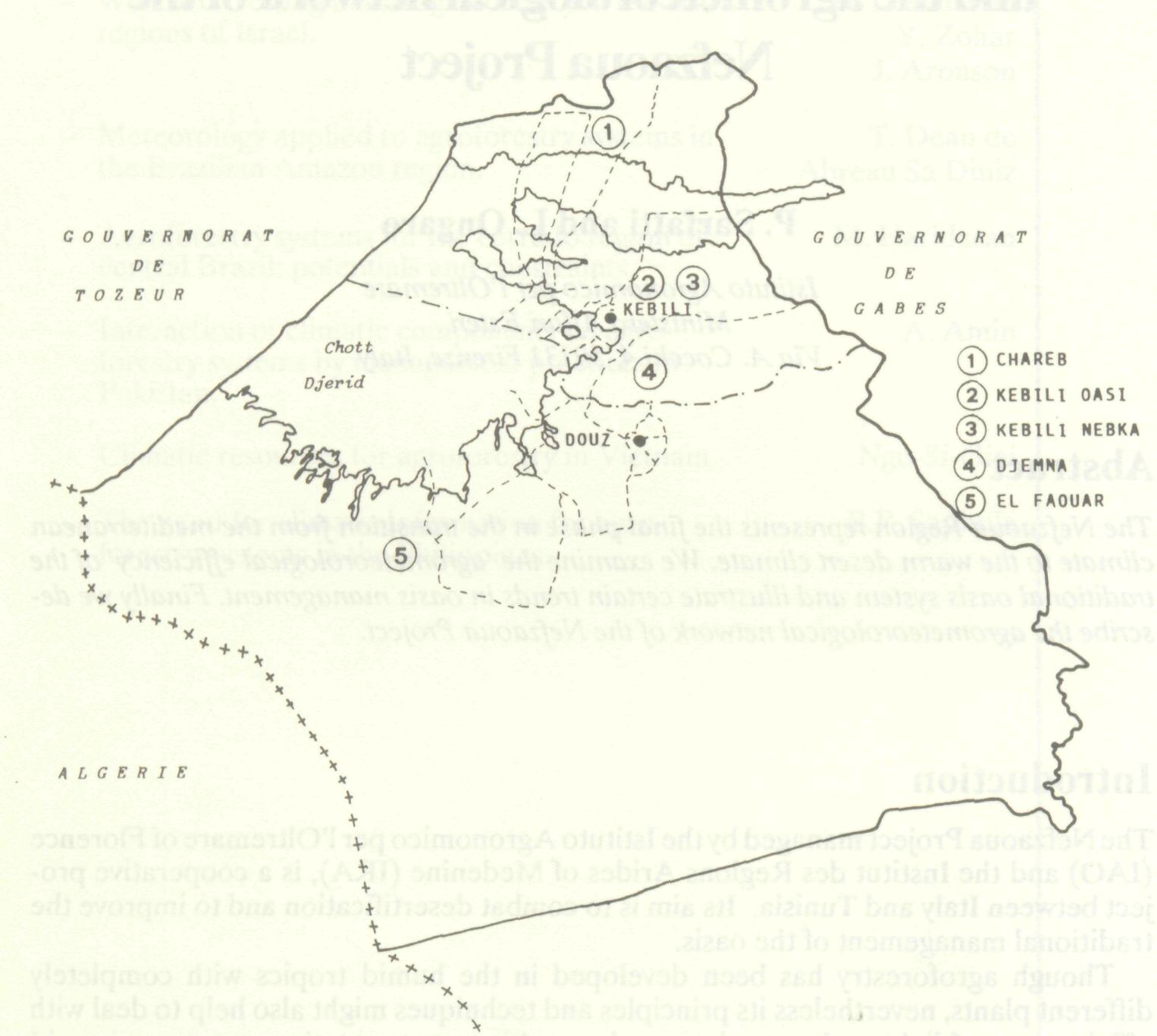
The region of Nefzaoua in southern Tunisia lies to the south of the Chott El Fedjedj, and to the east of the Chott El Djerid, two vast salty depressions that range in elevation between + 23 and -20 m asl. Eastwards are the Matmata mountains and southwards is the Sahara desert (Figure 1). A recent survey of the geomorphology, soils and vegetation of the area has been conducted by the Istituto Agronomico per l'Oltremare (Ongaro 1986) and a land units map has been drawn. The region has a tropical arid climate (Tave = 21 °C) with outbreaks of cold air from the Mediterranean sea; occasionally it is reached by the edges of the frontal depression systems crossing the upper latitudes. Throughout the entire zone the scanty and variable rainfall (90 mm per year) coincides with the period of lowest temperatures.
Agriculture is practiced exclusively in the oasis; the surrounding steppes are grazed by camels, goats and sheep. Traditionally vegetation in the oasis is structured on three levels: 1st level, date palms; 2nd level, fruit trees (olives, figs, pomegranates, almonds and apricots); 3rd level, fodder plants (alfalfa and barley) and vegetables. Fields are small and surrounded by hedges of palm leaves; the irrigation and drainage network is very close and plants are irrigated by submersion. The soils have a great percentage of sand and silt and, by consequence, have a very low cation exchange capacity. Therefore the manure used to maintain their fertility is a very important factor and also contributes to increased soil available water capacity. Commonly the oasis is protected from the outside by one to three shelterbelts of non-living barriers. The components of the whole system (vegetation structure, irrigation and drainage, hedges and shelterbelts, manure) contribute to create the 'oasis effect' leading to a reversal in the ratio between turbulent latent heat flux density and net all-wave radiation flux density (Flohn 1971; Oke 1978). The traditional management of the oasis has created a very complex system with the integration of agriculture and rangelands that cope quite well with the extreme environmental conditions.
Recently a decline in the productivity of many oases has led to a change of the system. Certain trends can be discerned:
All these management modifications affect many agrometeorological parameters inside the oasis (temperature, global and net radiation, wind speed, potential evapotranspiration, etc). On the other hand desertification in the surrounding steppes has been accelerated by climatic factors as well as by overgrazing with the consequence of increased heat advection from the areas in which the oases are embedded. Thus the traditional agro-ecosystem is being replaced by a more 'simple' but probably more unstable one, the long term validity of which has yet to be shown.
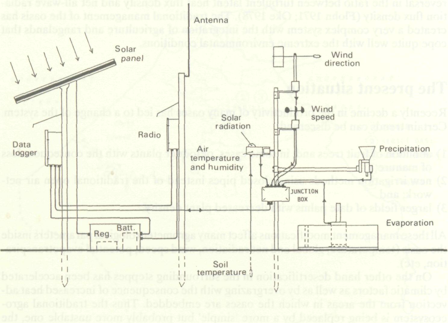
To monitor the present situation and to assess the validity of possible new proposals, an agrometeorological network will be implemented during 1987, as a part of the Nefzaoua Project. The network will be composed of five peripheral stations and a central unit in Kebili for data processing and storage. The meteorological variables to be measured include: precipitation, air temperature and humidity, solar radiation, wind speed and direction, evaporation and soil temperature (Figure 2). Data will be sampled every two minutes, pre-processed and transmitted automatically by radio to a personal computer. Data will also be stored at the local stations on solid state memory modules with a thirty-day data capacity. Solid state modules will be interchangeable and con-nectable to the computer by an interface. All the peripheral components will have a working range from -50 °C to +125 °C. The stations that don't 'see' Kebili will be connected by two radio repeaters. The network has been designed to be reliable and user-friendly (Benincasa et al. 1984; Sarfatti 1986). The network will also provide 'ground-truth' for a long-term remote-sensing experiment that will be conducted after 1988 by IAO .nd by the Italian National Research Council (CNR) to monitor desertification processes and oasis 'health' utilizing Land-sat TM and TIROS AVHRR images.
Benincasa, F., G. Fasano and A. Materassi. 1984. Un sistema automatico per il rile-vamento dei parametri agrometeorologici. Riv. Agron. 18: 220-224. Flohn, H. 1971. Saharization: natural causes or management? Special Environmental Rep. No. 2. Geneva: World Meteorological Organization. Oke, T.R. 1978. Boundary layer climates. London: Methuen & Co. Ongaro, L. (ed.). 1986. Le risorse natural! del Nefzaoua (Tunisia): Carta delle unita di terre dell'area Kebili-Douz. Riv. Agric. Subtrop. Trop. 80:165-310. Sarfatti, P. 1986. La rete agrometeorologica del progetto Nefzaoua. Riv. Agric. Subtrop. Trop. 80: 311-320. |