![]()
An e-publication by the World Agroforestry Centre
METEOROLOGY AND AGROFORESTRY

|
|
An e-publication by the World Agroforestry Centre |
|
METEOROLOGY AND AGROFORESTRY |
|
|
section 3 : regional examples Climatic resources for agroforestry in Vietnam Ngo-Si-Giai
Hydrometeorological Service of Vietnam
Abstract In Vietnam forests cover about 75% area of the country. They play a very important role in the formation of climate, water resources, soil, environmental conditions, and forest eco-logical systems and they are greatly influenced by hydrometeorological conditions too. In forest zones of Vietnam with different ecological conditions there is a meteorological and agrometeorological station network founded long ago. The application of meteorological and agrometeorological information to planning and management of agroforestry systems has gained in importance as it has intensified day by day. The humid and tropical climatic resources in the forestry of Vietnam, especially in mountainous areas of Tay nguyen (the Highland of the Central part of Vietnam), the East of South Vietnam, North East and North West of North Vietnam are multiform and rich. That is why forest flora has high potential productivity. Unfavourable conditions such as dry and hot wind, drought, heavy rain, flood, fire, landslide, erosion and unrational exploitation have caused remarkable changes in hydro-meteorological regimes. Here, there are also proposals in the directions of the study and methods of the applications of agrometeorological information (methods forecast of forest fire and methods of forecast of biomass growth of forest trees in every year) in the planning and management of agroforestry systems, especially in new planting and regeneration of forests.
In Vietnam, forests and mountains cover about 75% of the country. Climatic resources of Vietnam are multiform and play a decisive role in the formation of forest systems and their yield. The estimation of climatic resources is of great significance in planning, management and exploitation of agroforestry systems. In the various forest zones, the Hydrometeorological Service of Vietnam has founded a meteorological and agrometeorological station network long ago. Since 1960, hydro-meteorological and agrometeorological data have been actively used in the planning and management of the forest zones. This paper discusses two problems: estimation of climatic and forest resources of Vietnam; and the application of meteorological information in forecasting forest-fire danger.
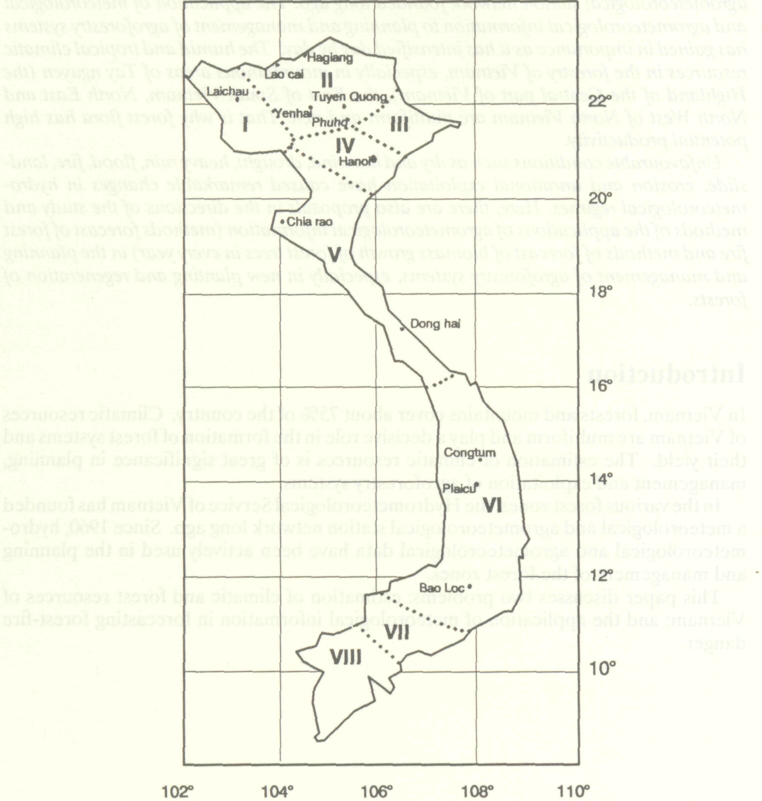
Forests in Vietnam are divided into eight main zones:
The Main forest zones in Viêtnam
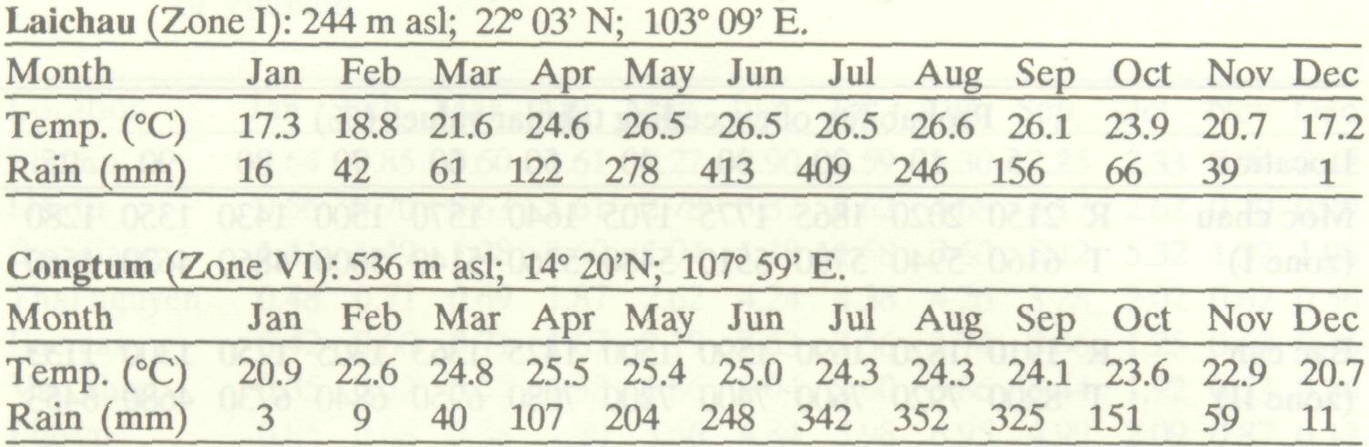
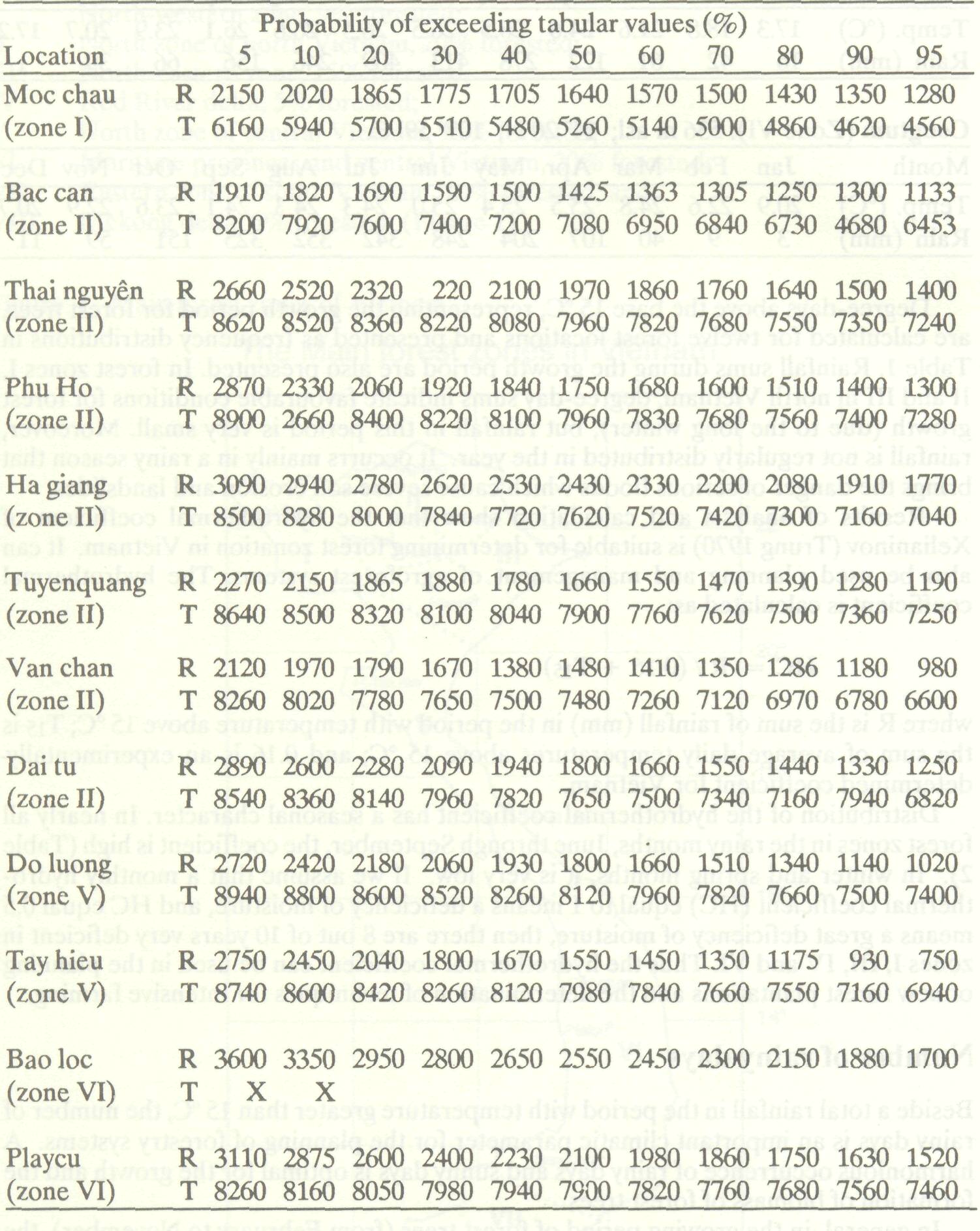
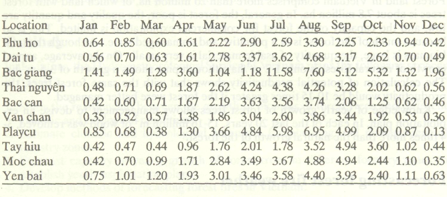
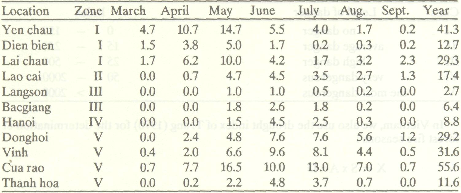
Degree-days above the base 15 °C, representing the growth period for forest trees, are calculated for twelve forest locations and presented as frequency distributions in Table 1. Rainfall sums during the growth period are also presented. In forest zones I, II and III in north Vietnam, degree-day sums indicate favourable conditions for forest growth (due to the long winter), but rainfall in this period is very small. Moreover, rainfall is not regularly distributed in the year. It occurrs mainly in a rainy season that brings the danger of serious floods which cause severe soil erosion and landslides. Results of analysis and calculation show that the hydrothermal coefficient of Xelianinov (Trung 1970) is suitable for determining forest zonation in Vietnam. It can also be used planning and management of agroforest systems. The hydrothermal coefficient is calculated as: HC = R / (0.16 + T15) where R is the sum of rainfall (mm) in the period with temperature above 15 °C; T15 is the sum of average daily temperatures above 15 °C; and 0.16 is an experimentally-determined coefficient for Vietnam. Distribution of the hydrothermal coefficient has a seasonal character. In nearly all forest zones in the rainy months, June through September, the coefficient is high (Table 2). In winter and spring months, it is very low. If we assume that a monthly hydro-thermal coefficient (HC) equal to 1 means a deficiency of moisture, and HC equal 0.5 means a great deficiency of moisture, then there are 8 out of 10 years very deficient in zones I, III, IV and VI. Thus the hydrothermal coefficient can be used in the planning of new forest plantations and the determination of techniques for intensive farming.
Beside a total rainfall in the period with temperature greater than 15 °C, the number of rainy days is an important climatic parameter for the planning of forestry systems. A harmonious occurrence of rainy days and sunny days is optimal for the growth and the formation of biomass of forest trees. In general, in the growing period of forest trees (from February to November), the number of rainy days in zones I, II and III is rather regularly distributed with 14-20 rainy days per month. In such months each two days has one rainy day, especially in central part of Vietnam (zone V) the number of rainy days in every month from March to June is less than the one of other months. In Playcu (zone VI), the number of rainy days in spring months is very small: 0.1-0.9 days per month. Table 1 Probability of exceeding sums of temperature > 15 °C and rainfall in months with average temperature > 15 °C (base 1960 -1980).
Total rainy days in forest zones show small differences. Maximum is 154 days in the north (Bacquang, zone II) and 189 in the south (Bao loc, zone VI). However in order to estimate more correctly we calculated the number of rainy days with probability 80% in the period with temperature greater than 15 °C and found that there are 8 out of 10 years in which the number of rainy days in zones I, II, III and IV is no more than 120 days; and in zones V and VI is no more than 140 days. Reality shows that the period with average temperature more than 15 °C in Vietnam is usually year-long. Therefore, the greater the number of rainy days with probability of more than 80%, the greater the productivity and biomass of the forest zones. Table 2 Average monthly hydrothermal coefficient in different forestry zones of Vietnam.
In 1968,1969,1970 and 1971, climatic surveys in many forest zones showed that hot and dry winds cause great damage to forest trees. The meteorological factors causing the damage are high temperature, low atmospheric humidity, and low soil moisture resulting from low rainfall. The criteria for a hot-and-dry day are Tmax > 37 28M C, Rmin < 50% and rainfall in the previous two days < 5 mm. In the forest zones of Vietnam, hot and dry days are common from March to October (Table 3), and are the main cause of forest fires. Table 3 Number of hot and dry days (Tmax 37 °C; Rmin 50%) in forestry zones of Vietnam.
Forest land in Vietnam comprises more than 20 million ha, of which land with forest trees is about 7.8 million ha. In general, the forest is poor, the quality and quantity are low, and the capacity of the forest for commercial exploitation is limited. This is so because much of the forest is in a primitive and unmanaged state. Although the total biomass is large, the quantity of usable material is very small. On the average, annual growth of natural forest is only 1-2 m3 /ha although pine shows a growth of 3-5 m3 /ha. The calculation of potential productivity shows that with the same forest trees, the productivity would be 10-15 times greater if the forest were better managed. Knowledge of yearly growth of forest trees allows management to devise an exploitation plan. In each of the last 20 years, 15-16 million m3 of wood was removed, 3-4 times more than the natural growth of the forest.
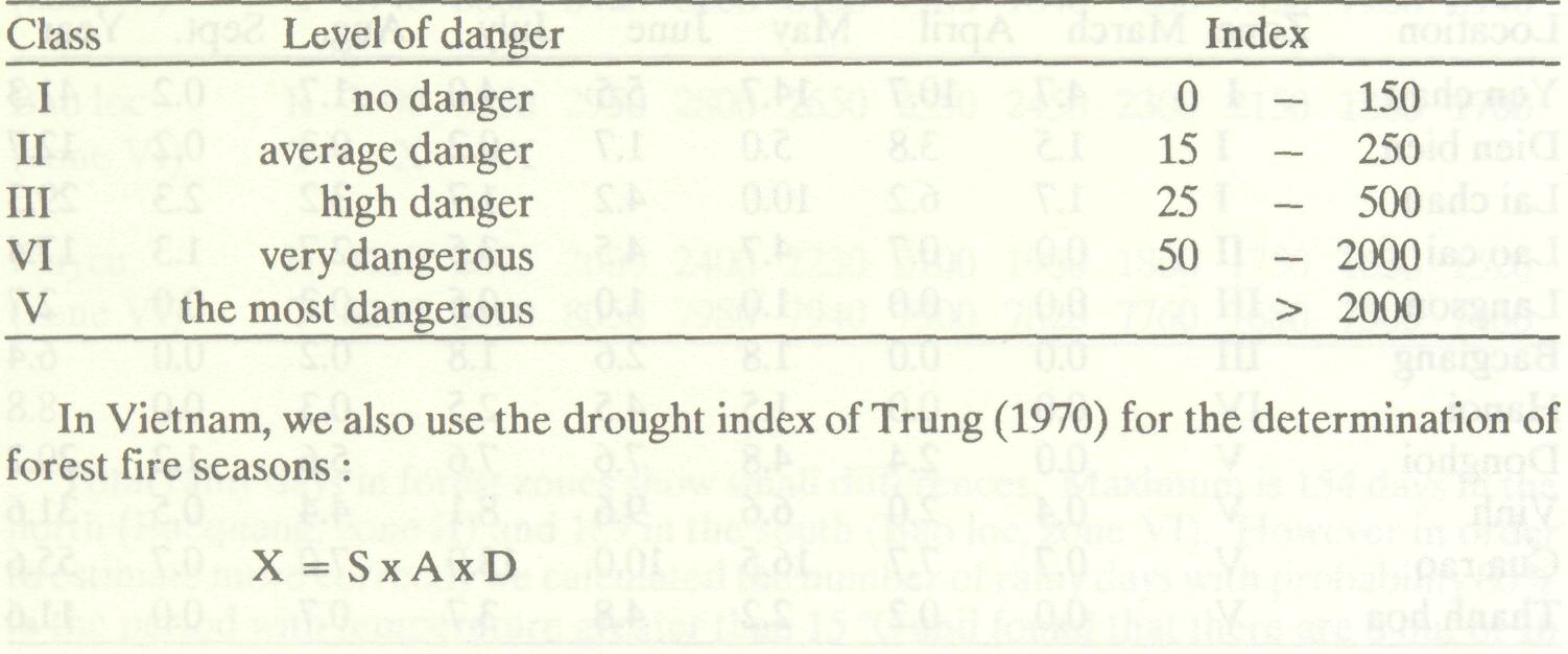
Forest fires have rapidly reduced the forest area of Vietnam. In the last 20 years fire has damaged about 10 million m3 of wood. Forest fires from natural causes are rare and appear only in meteorologically favourable conditions. The forest fire season is usually from November to April in the highlands of central Vietnam. In the north it is from May to October. Forest fires usually occur in the time from 1300 to 1900. In order to effectively and actively defend the forest resource, it is necessary to predict the potential for fire in each zone. In Vietnam, it was determined that the main meteorological factors that cause forest fire are air temperature and humidity, wind, and soil moisture. We have used two methods to forecast fire danger: the methods of Nesterov and Trung (Trung 1970). According to Nesterov, the complex index, D, is the sum of products of saturation vapour pressure deficit and the air temperature at 1300 of all days since the last rain: D=K x D-1 + Ta x Td where D-1 is the value of the index on the previous day; K is a rainfall coefficient which has the value 0 for a rainy day and 1 for a dry day; Ta is the air temperature at 1300; and Td is the dew point temperature at 1300. The index is divided into the following classes:
where X is the drought index; S is the number of dry months with real rainfall < 2 x average temperature; A is the number of months with rainfall < 1 x average temperature; and D is the number of months with rainfall < 5 mm.
In the future, the Hydrometeorological Service of Vietnam plans the following services to forestry:
References Trung, Thai Van. 1970. Ecogenesis and classification of forest vegetation of Vietnam. Hanoi: Publishing House of Sciences and Technology. (In Vietnamese). |