![]()
An e-publication by the World Agroforestry Centre
METEOROLOGY AND AGROFORESTRY

|
|
An e-publication by the World Agroforestry Centre |
|
METEOROLOGY AND AGROFORESTRY |
|
|
section 8 : miscellaneous The climatic aspects of the 1982/83 wildfires in Nigeria A.B. Oguntala
School of Forestry, Forestry Research Institute of Nigeria
Abstract The forest-fire climate of parts of Nigeria was studied in relation to afire incidence which destroyed thousands of hectares of forest and farm plantations in different parts of the country during 1982/83 dry season. Over 70% of the land area of Nigeria experiences annual bush fires and economic losses as a result of the 1982/83 fire incidence alone was more than N90 million ($30.00 million). It was observed that a declining number of rainy days in different parts of the country coupled with increasing maximum air and soil temperature and decreasing relative humidity (a favourable fire-climate or high fire - danger rating) predisposed the crops (forestry and agriculture) to fire risks. After the fire regeneration in exotic trees like Pinus caribaea and Gmelina arborea was higher than of indigenous species like Khaya ivorensis, Triplochiton scleroxylon and Terminalia ivorensis. The results of the study indicate that fire incidence could be predicted from available meteorological data. A fire - prediction I control system is urgently needed for the country to prevent annual economic losses, and environmental disasters.
In Nigeria fire has been part of the environment for centuries. The savannah covering 83% of the land is still being subjected to annual bush fires, while the rain forest is being cut down in large areas and burned during land preparation for agricultural and other plantation purposes. Apart from the human factor, frequent drought occurrences in Nigeria have been predisposing the vegetation to annual fires. Climatic studies in southern Nigeria (Oguntala 1975; Oguntala and Oguntoyinbo 1982) indicate that there has been a significant change in the number of rainy days in parts of the country and that this has contributed to the spread of bush fires. It has been suggested that bush fires can be predicted, by making use of climatic information (Reifsnyder 1978; Oguntala 1982). The need to control bush fires is becoming increasingly important in the tropics in view of the increasing cost of damages done by fire to agricultural and forest plantation projects. This paper diagnoses the climatic factors that predisposed farms and forests to fire in the 1982/83 dry season. The extent of damage to crops in parts of the country is examined from both economic and ecological view points.
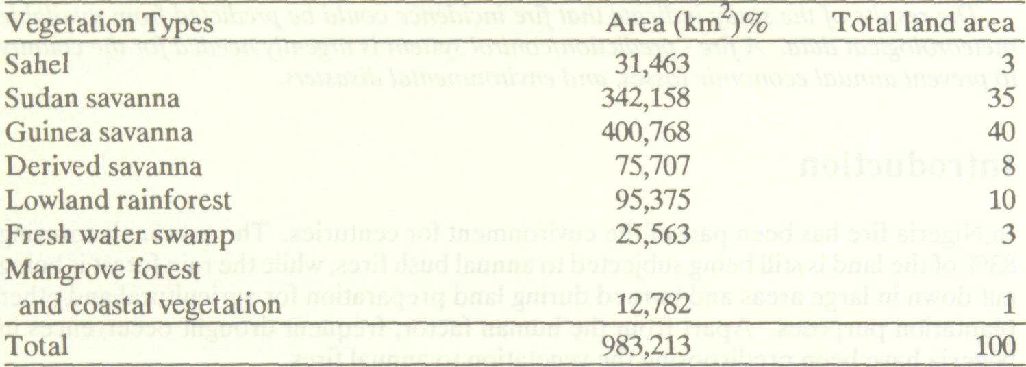
Table 1 gives the summary of various vegetation types in Nigeria. These vegetation types have varied bioclimates which are related to their structure and species composition. Out of Nigeria's 983,213 km2 area, 73% of the land consisting of all vegetation types has medium to high fire danger rating during the dry season. Before the 1982/83 drought occurrence, the high forest had a very low fire danger rating; however, with increasing human activities in the area, and increasing drought susceptibility, the area consisting of about 10% of the land area of the country experienced serious fire occurrences during 1982/83. Traditionally, major parts of the savannah (sudan, guinea and derived) consisting of 83% of the total land area of 818,633 km2 are burned annually. Areas which totally escape annual fires include the Sahel, fresh water swamp forest, and the coastal mangrove vegetation constituting only 7% of the land area or 69,838 km2 . The Sahel has no vegetation to be burned while the swamp/coastal vegetation is water-logged most of the year. Increasing human activities particularly shifting cultivation, grazing, and timber exploitation occur in over 70% of the land area of the country (forest and savanna) which are burned annually. Fire is commonly used in shifting cultivation practices, while cattle herdsmen use fire to clear old grasses to provide green flushes during the dry season. The sudan and northern guinea savannah usually get burned first, while the most severe bush fires occur in the southern Guinea savannah which later spread to the high forest zone. Table 1 Area of vegetation types in Nigeria
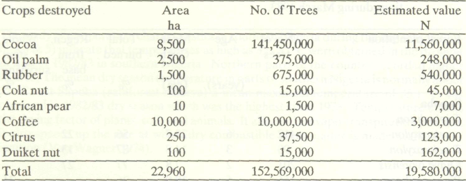
Annual bush fires have been a part of the Nigerian land-use problems for years. Indiscriminate and malicious bush burning has resulted in colossal economic losses to Nigeria for many years. Huge losses are recorded annually of forest plantations and food crops. Wildlife is destroyed resulting in the depreciation of tourism potentials. Over 17,000 ha of forest plantation including those of two Agriculture Development Projects were burned in the 1982/83 dry season alone (Federal Department of Forestry 1984). Assuming there is a 50 per cent recovery, this is equivalent to a loss of about N- 90 million in one fire year alone. This does not include losses in forest resources outside plantations and also wildlife resources. Table 2 gives the details of losses in one of Nigeria's 19 states. The total loss was equivalent to about N-19 million based on existing compensation rate in the state. The losses in the drier northern states of Nigeria are most likely to be higher. The practice of bush burning in Nigeria is very common and is reducing the forest estate annually. It is causing rapid vegetation changes which ultimately encourage desert encroachment. Table 2 Effects of drought/fire in Bendel State, Nigeria 1982/83
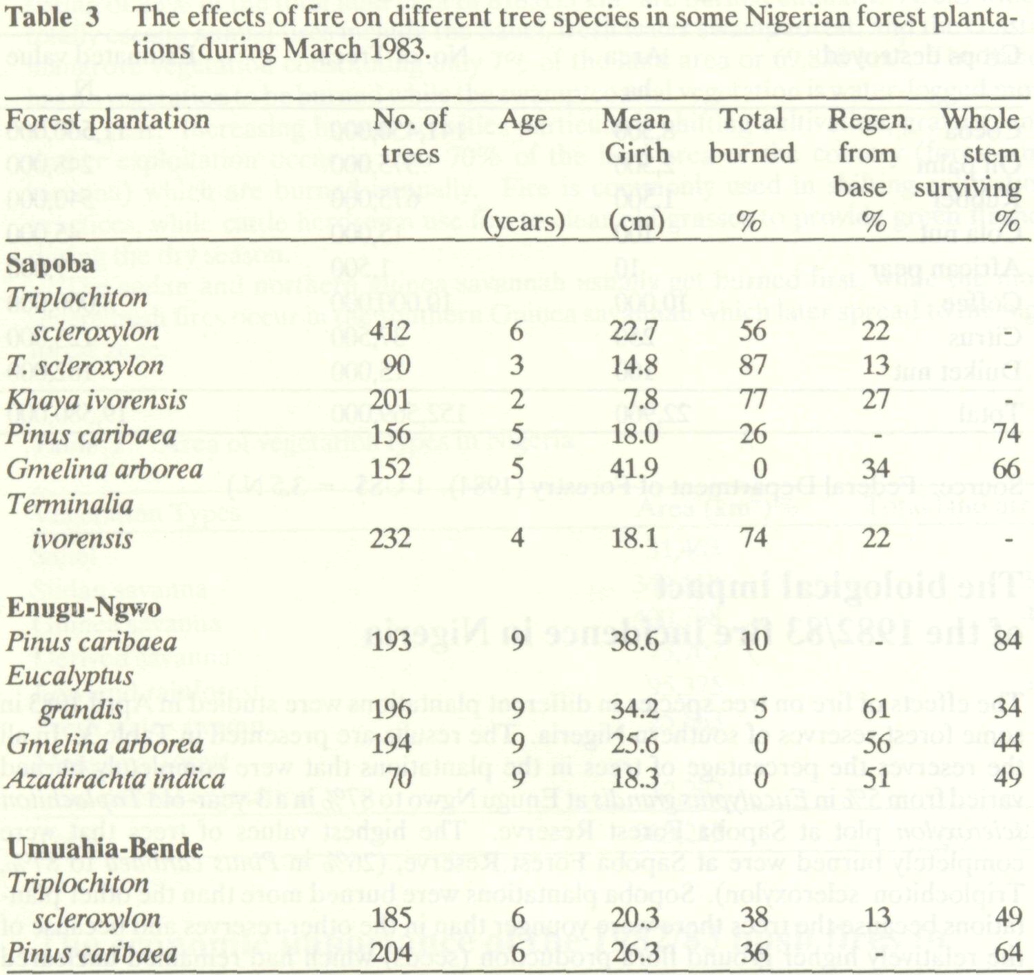
The effects of fire on tree species in different plantations were studied in April 1983 in some forest reserves of southern Nigeria. The results are presented in Table 3. In all the reserves the percentage of trees in the plantations that were completely burned varied from 5% in Eucalyptus grandis at Enugu Ngwo to 87% in a 3-year-old Triplochiton scleroxylon plot at Sapoba Forest Reserve. The highest values of trees that were completely burned were at Sapoba Forest Reserve, (26% in Pinus caribaea to 87%, Triplochiton scleroxylon). Sopoba plantations were burned more than the other plantations because the trees there were younger than in the other reserves and because of the relatively higher ground flora production (seeds) which had remained uncleared prior to the fire incidence. Sapoba also has higher rainfall generally than the other sites; this factor also contributes to the development of a higher fuel load at Sapoba than in the other sites. There were also differences in the responses of individual tree species to fire. The species with the highest resistance to fire was the 9-year-old Pinus caribaea with values as high as 84% at Enugu - Ngo and 74% survival at Sapoba. Tectona grandis at Umuahia - Bende also had 77% survival. In both species the bark of the trees gave a great resistance to the fire, burned barks peeled off, while new ones were developed. Both species are exotic trees being introduced into most parts of the country. The trees with the least resistance to fire were the indigenous high forest tree species also being developed as plantation species, following large scale clearance of the rainforest, the natural habitat of the species (Table 3). The species include Triplochiton scleroxylon, Kaya ivorensis and Terminalia superba. These species have no natural resistance to fire, as fire has never been part of their environment, unlike the savanna species. In most of the species, regeneration was from the base (i.e., the root stock) if the whole stem had been lost to the fire. Fire, therefore, has to be kept away completely from such plantations.
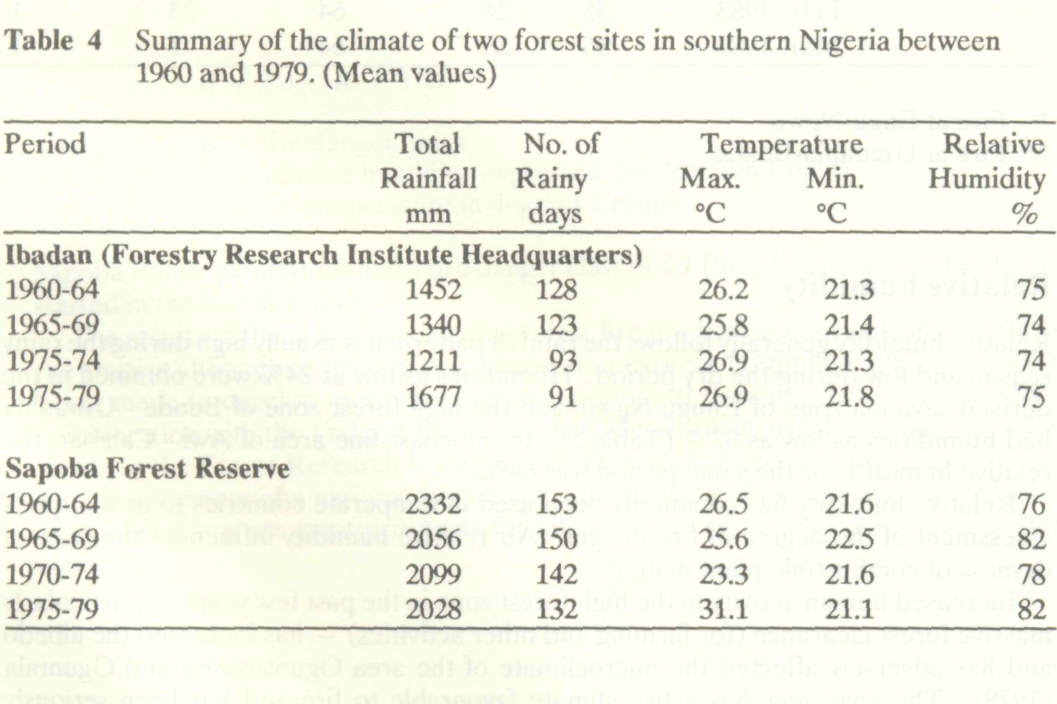
Precipitation Precipitation is one of the elements of weather used to predict fire occurrences because of its direct relationship with fuel moisture content within plant ecosystems. In Nigeria, there is a well-defined dry season, that is a period of low or no precipitation. The length of the dry season varies with different vegetation types in the country. The dry season periods extends from 7 - 8 months in arid northern part of the country to only about one month in the wet coastal areas of the country. The length of the growing season (rainy season) is usually short in the savanna region of the country. The number of rainless period is long and is increasing (Table 4). The decrease in number of rainy days has been increasing the susceptibility of the country to drought and storms (floods); drought because of the reduction of the growing season of plants due to lack of rainfall and storms because of the spread of the total annual rainfall has been shortened resulting in higher rainfall per day (Oguntala and Oguntoyinbo 1982). The dry season starts from August in some parts of the Sahel zone before spreading to the rain forest zone in November.
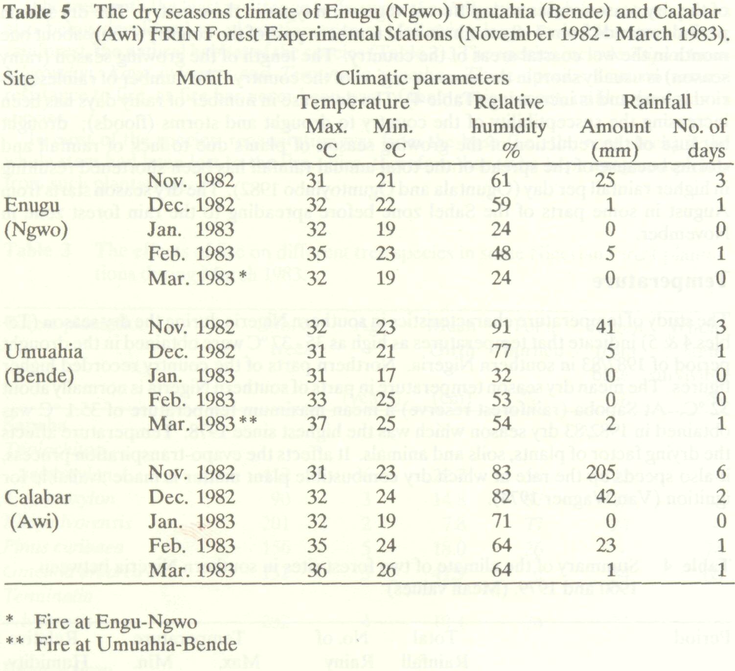
The study of temperature characteristics in southern Nigeria during the dry season (Tables 4 & 5) indicate that temperatures as high as 35 - 37 °C were obtained in the drought period of 1982/83 in southern Nigeria. Northern parts of the country recorded higher figures. The mean dry season temperature in parts of southern Nigeria is normally about 32 °C. At Sapoba (rainforest reserve) a mean maximum temperature of 35.1 °C was obtained in 1982/83 dry season which was the highest since 1978. Temperature affects the drying factor of plants, soils and animals. It affects the evapo-transpiration process, it also speeds up the rate at which dry combustible plant matter is made available for ignition (Van Wagner 1974).
Relative humidity generally follows the rainfall pattern: it is usually high during the rainy season and low during the dry period. Humidities as low as 24% were obtained in the derived savanna zone of Enugu Ngwo; and the high forest zone of Bende - Umuahia had humidities as low as 32% (Table 5). In the coast-line area of Awi - Calabar, the relative humidity for the same period was 64%. Relative humidity has commonly been used in temperate countries to give a quick assessment of the degree of fire danger. Air relative humidity influences the state of dryness of combustible plant matter. Increased human activity in the high forest zone in the past few years particularly massive forest clearance (for farming and other activities) has increased the albedo and has adversely affected the microclimate of the area Oguntoyinbo and Oguntala (1978). The zone now has a fire climate favourable to fire and has been seriously predisposed to bush fires.
In order to be able to predict forest fire weather, standard meteorological stations were set up in different forest reserves in parts of Nigeria. Data on rainfall, air and soil temperature, relative humidity, evaporation and wind speed, are obtained daily from these stations. The summary of the climatic data for Ibadan and Sapoba are presented in Table 4. A significant decrease in the number of rainy days in Ibadan during the period from 1960 to 1979 was observed. Ibadan is the northern tip of the rainforest. A non- significant decrease in the number of rainy days was observed at Sapoba. This decrease in number of rainy days which was common in most parts of Nigeria has been predisposing the vegetation to fire. The growing season has been shortened and the dry matter production particularly in the dry season has been increasing (Oguntala 1979, 1981). The summary of the dry-season climate in forest plantations of southern Nigeria is presented in Table 5. It is characterized by abnormally high temperatures (for southern Nigeria) particularly during February/March, and by very low humidities associated with low rainfall. An accidental forest fire started at Sapoba Forest Reserve in the late afternoon of March 1983. Microclimatic data from different plantation plots in the reserve were analyzed to determine fire weather conditions. Maximum temperature at 1800 in the forest plantation was 34 °C compared with 37 °C in the open, while the relative humidity at 1600 was 47% in the open compared with 65% in the plantation. The fire danger index was calculated using the modified Angstrom forest fire predicting equation (Reifsnyder 1978) B = 3.3 - 5R + T/10 where B= fire danger index R=relative humidity expressed as a fraction from o - 1 T= air temperature in degrees Celsius. Sapoba Forest plantations had a fire danger class of 4.1 (high fire danger) when the fire started in the late afternoon. The results of this study indicate that forest fire prediction is feasible in Nigeria and the tropics although at present it is almost non-existent (Oguntala 1982). Efforts are being made to develop more synoptic meteorological stations. This is being done in collaboration with the Federal Department of Meteorology which supplies the instruments to the Forest Research Institute. The Institute collects and processes the data. The development of a national fire danger forecasting and rating system is still inadequate, but there are great prospects for improvement of facilities to cover the entire country.
Federal Dept. of Forestry. 1984. Land-use in Nigeria: the case for forestry. Memorandum prepared for the National Land-use Panel, Fed. Govt. of Nigeria 1977. Oguntala, A.B. 1975. Climatic studies in three forest sites of south-western Nigeria. Paper for the 6th Annual Conference of the Forestry Association of Nigeria Calabar, 1975. Oguntala, A.B. 1979. Seasonality of litter and ground flora biomass in Sapoba Forest Reserve, Nigeria. Trop. Ecol. 20:140-146. Oguntala, A.B. 1981. Structure composition and litter fall in different forest types in south-em Nigeria. Paper for the XVII IUFRO World Congress, Kyoto, September 1981. Oguntala, A.B. 1982. Wildland fires particularly in tropical regions. World Meteorological Organization. CAgM Report No.10. Oguntala, A.B. and J.S. Oguntoyinbo. 1982. Urban flooding in Ibadan: a diagnosis of the problem. Urban Ecol. 7:39-46. Oguntoyinbo, J.S. and A.B. Oguntala. 1978. Aspects of the forest climate in southern Nigeria. In Conference on Forest Meteorology, August 1978, Ottawa, Canada. World Meteorological Organization Pub. No. 527. Reifsnyder, W.E. 1978. Systems for evaluating and predicting the effects of weather and climate on wildland fires. World Meteorological Organization Special Report No.ll, WMO No. 4%. Van Wagner, C.E. 1974. Structure of the Canadian forest fire weather index. Canadian Forestry Service. Publ. 1333. |