![]()
An e-publication by the World Agroforestry Centre
METEOROLOGY AND AGROFORESTRY

|
|
An e-publication by the World Agroforestry Centre |
|
METEOROLOGY AND AGROFORESTRY |
|
|
section 4 : measurement and analysis of agroforestry experiments Agroclimatic analysis for semi-arid climatic conditions
P.S.N. Sastry
Division of Agricultural Physics
Abstract Since development of Köppen's climatic classification, several indices have been used to delineate climatically homogeneous regions and some of them have been applied to agroclimatic classification in several countries. The delineated regional patterns, whether based on rainfall or climatic water balance which includes the soil factor, do not generally differ from one another and one technique can be considered as good as the other. Semi-arid regions like the Indian subcontinent being characterized by both spatial and temporal variability and advective conditions during the break monsoon periods, the effect of climate on different phenophases assumes importance. The need for a phenology-based analysis of rainfall probability for agroclimatic purposes for major crops is brought out.
Delineation of climatically homogeneous regions has been an important aspect of agroclimatic analysis that received extensive attention since the 19th century. Mainly, such an analysis sought to explain natural vegetation-climate relationships based on rainfall, temperature and potential evapotranspiration either singly or in combination. Inclusion of soil moisture holding capacity and water balance concepts developed by Thornthwaite was considered to provide a rational basis for climatic classification. These techniques serve the limited purpose of identification of natural climatic boundaries that represent the different plant communities, soil groups and land forms in terms of numerical climatic data and bring out vegetation-climate associations. While climatic classification is a preliminary step, it is often supplemented by rainfall reliability analysis and presented in the form of rainfall probability maps in order to meet the requirements of crop planning. The form that such a rainfall reliability analysis should take to meet specific requirements such as those of agroforestry or crop planning does not seem to have received adequate consideration. The need for inclusion of a crop parameter into such an analysis is discussed below.
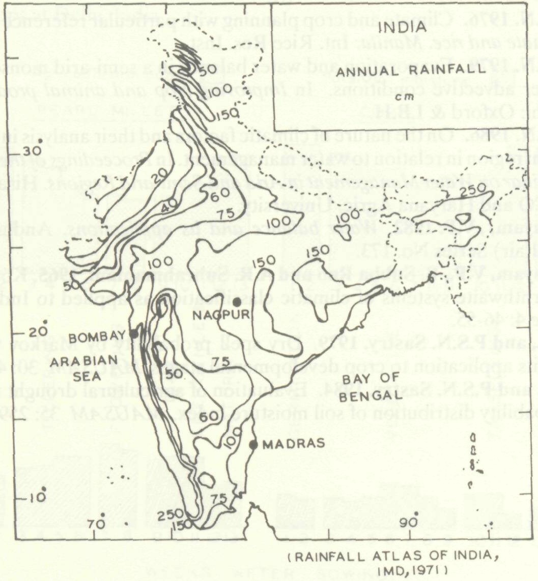
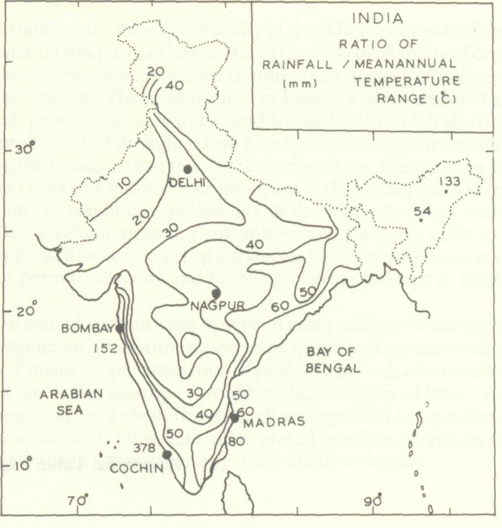
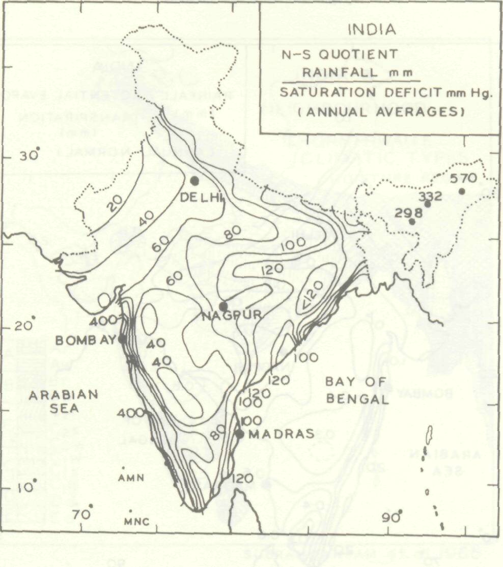
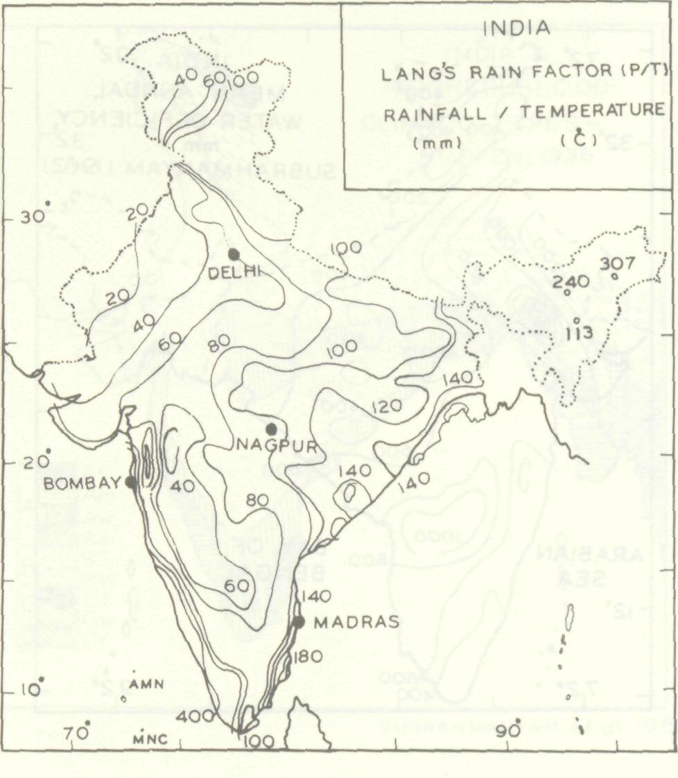
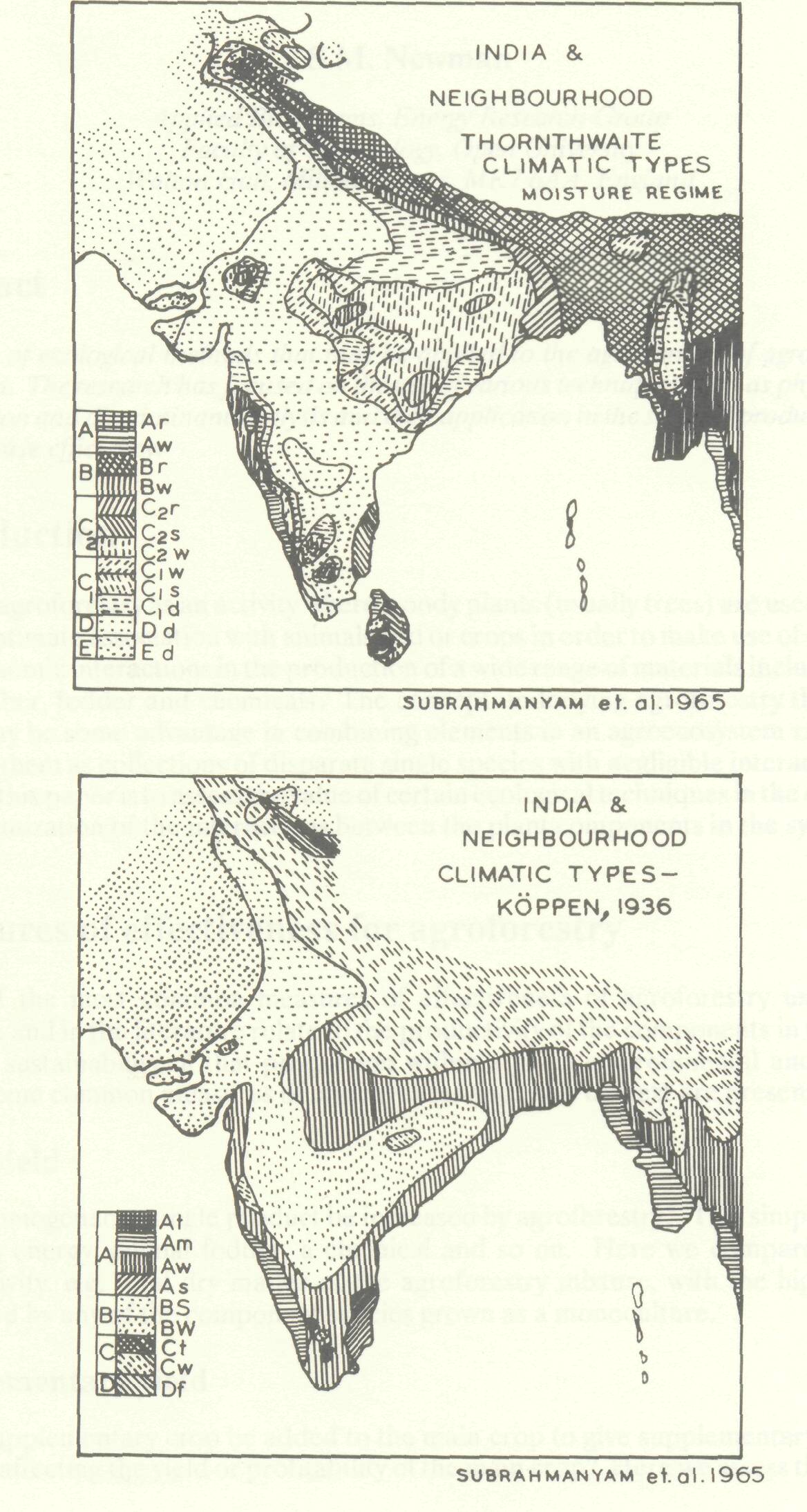
An examination of normal annual rainfall distribution map of India in comparison with the patterns that are obtained using several climatic indices that have been proposed from time to time climatic types according to Koppen's system based on rainfall and temperature, Thornthwaite's system based on moisture regime using climatic water balance (Subrahmanyam, Subba Rao and Subramaniam 1965), Meyer's N-S quotient, Lang's rainfactor, rainfall versus mean annual temperature range or potential evapo-transpiration (Figures 1, Appendix) indicates a striking similarity in the nature of delineated zonal patterns. The regions of mean annual water deficiency (Subrahmanyam 1982), while yielding valuable quantitative estimates for purposes of long term planning of water resources of a region, do not in any way differ from the pattern that could be expected from the normal rainfall distribution map. Thus, while the individual indices evolved for different purposes have their own significance, as far as delineation of areas of climatic homogenity in general is concerned, it could be concluded that one technique is as good as the other for identifying climatic types. Except for the differences in the quantitative coefficients or magnitudes, the different indices clearly point out the dominant role played by rainfall amount and its spatial distribution in relation to the physiographic features of the region in determining the climatic types of India, which is subtropical and predominated by semi-arid climatic conditions over a large part.
In the season when rainfall is the dominant factor, its non-occurrence for a few days in the semi-arid tracts is associated with periods of high temperature and increased evaporative conditions (Sastry 1976). The Indian subcontinent is characterized by:
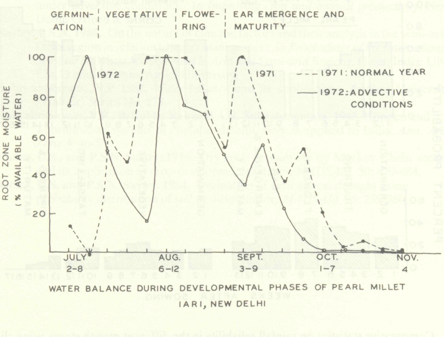
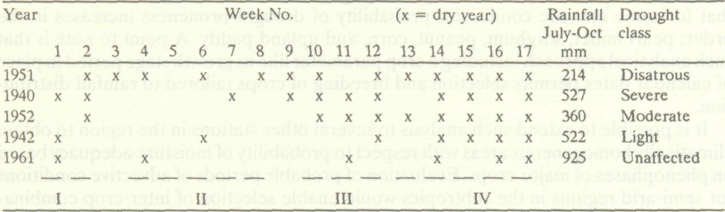
The break monsoon situations were found to bring in advective conditions (Sastry 1979) which may cause yield reduction even in an irrigated crop such as paddy (Sastry 1986) due to atmospheric stress when there is energy transfer from the surroundings to the evaporating surface. Such an effect is also reflected in the water balance in the root zone in particular seasons as shown in Figure 2 for different growth phases of pearl millet crop. It is significant to note that because of high temporal variability, such situations occur at different crop growth stages in different years and irrespective of the total seasonal rainfall the drought severity varies from year to year, such as that illustrated for corn crop in Table 1 (Appendix). Thus the growth stage of any particular crop at which adverse environmental conditions occur in different years is of significance as this becomes an important yield determining factor. This is particularly so, since susceptibility of crops to same adverse weather conditions differs between crop species or even from one growth stage to the other. In this context, relation of rainfall reliability or water balance probabilities to growth stages of major crops can be considered to provide a better base in agroclimatic analysis. For instance, information on meteorological drought probabilities if related to phenophases of crops grown in a region would enhance its practical value in planning cropping or agroforestry systems. On this basis, using the Markov chain model, Victor and Sastry (1979) developed two different cumulative probability nomograms for dry spell runs during monsoon season at Delhi using (a) calendar months (b) growth stages of pearl millet crop.
Table 1 Distribution of dry weekly periods starting July 1 in the crop phases of maize at New Delhi. (Sastry 1976)
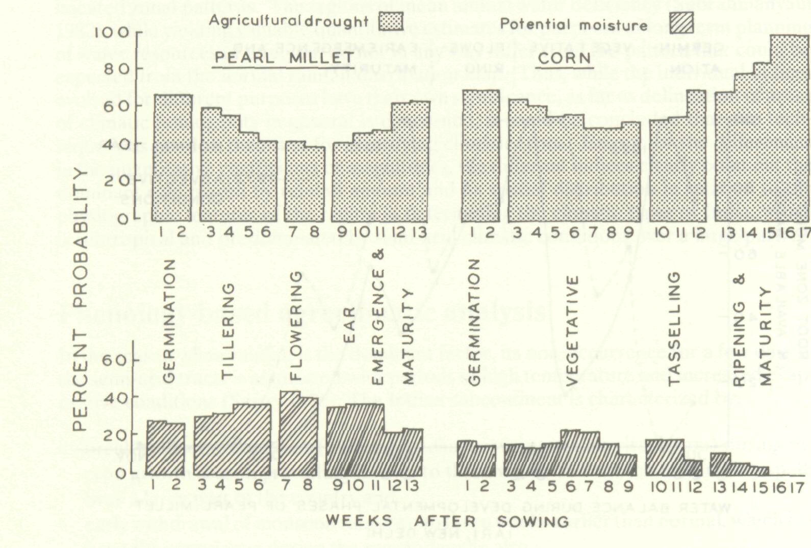
It is possible to extend such analysis to several other stations in the region to obtain climatically homogeneous areas with respect to probability of moisture adequacy based on phenophases of major crops. Evaluation of probable periods of advective conditions for semi-arid regions in the subtropics would enable selection of inter-crop combinations for provision of needed shelterbelts. Such an approach to agroclimatic analysis may be expected to lead to development of integrated agroforestry system for semi-arid regions which exhibit high temporal and spatial rainfall variability.
Sastry, P.S.N. 1976. Climate and crop planning with particular reference to rainfall. In Climate and rice. Manila: Int. Rice Res. Inst. Sastry, P.S.N. 1979. Evaporation and water balance in a semi-arid monsoonal climate under advective conditions. In Improving crop and animal productivity. New Delhi: Oxford & I.B.H. Sastry, P.S.N. 1986. On the nature of climatic factors and their analysis in the semi-arid Delhi region in relation to water management. In Proceedings of the International Seminar on Water Management in Arid and Semi-arid Regions. Hisar, India: UNESCO and Haryana Agric. University. Subrahmanyam,, V.P. 1982. Water balance and its applications. Andhra University (Waltair) Series No. 173. Subrahmanyam, V.P., B. Subba Rao and A.R. Subrahmaniam. 1965. Koppen and Thornthwaite systems of climatic classification as applied to India. Ann. Arid Zone 4: 46-55. Victor, U.S., and P.S.N. Sastry. 1979. Dry spell probability by Markov Chain model and its application to crop developmental stages. MAUSAM 30: 479-484. Victor, U.S. and P.S.N. Sastry. 1984. Evaluation of agricultural drought using probability distribution of soil moisture index. MAUSAM 35: 259-260.
|