Positive impact of soil
information service
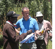
We've developed these
at resolutions that
will enable extension
agencies and others
to approach individual
farmers and discuss
interventions to improve
soil condition.
Soil degradation in Africa is so widespread that millions of farming families struggle to feed themselves – cereal
yields have barely risen over the past 30 years – let alone produce a surplus to sell. Restoring the health of Africa's soils is vital to tackling poverty which is why the African Soil Information Service (AfSIS) is so important.
Launched in 2009 with funding from the Bill and Melinda Gates Foundation and the Alliance for a Green Revolution in Africa (AGRA), the four-year project is conducting a systematic evaluation of soil health at 60
sites in 21 countries. "By the time the first phase of the project comes to an end, we will have produced a first-cut
map for the whole of sub-Saharan Africa," says World Agroforestry Centre soil scientist Keith Shepherd. This will provide a far more detailed evaluation of soil health than any previous studies.
An external review, conducted at the halfway stage of the project, described AfSIS as a 'unique scientific effort.' It praised the outstanding design and implementation of the
project, its ground-breaking use of infrared spectroscopy to assess soil health and the extensive training of national scientists.
"During the past year, we have devoted considerable effort to managing a rapidly expanding database, demonstrating the validity of the methods used to gather information and packaging information in different ways to satisfy a range of users," says Shepherd.
The project has produced reports on soil properties for each of the sites sampled. These provide feedback for extension agencies and agronomists on the main constraints to plant growth, with detailed information on salinity, pH and deficiencies in minerals such as phosphorus, potassium, manganese and zinc. This is just the sort of information required by individuals and organizations who wish to improve soil health and productivity.
During the past year, Tor-Gunnar Vågen, the principal investigator for the soil and ecosystem health component of AfSIS, has been working with his colleagues to create indices of soil condition. "We've developed these at resolutions that will enable extension agencies and others to approach individual farmers and discuss interventions to improve soil condition," he says. Data generated by AfSIS will also provide national authorities
with the information they need to design soil rehabilitation
strategies and identify areas of particular risk of degradation.
During 2010, AfSIS researchers developed a methodology for measuring soil carbon stocks, using data gathered both within and beyond the 60 sites. Baseline carbon studies could be particularly useful for organizations that wish to enter the carbon market, or track changes over time. One study, carried out for the Kenyan Forestry Research Institute and the Kenya Wildlife Service, is mapping soil carbon stocks in and around Mount Kenya. Others were commissioned by the East Africa Dairy Development Project and by a private organization managing rangelands in Laikipia, Kenya.
One of the key recommendations made by the project review was that AfSIS should become a demand-driven service-provider with a business mindset. "Over the next year, we will be devoting more time to working out how to get commercial soil-testing laboratories and others interested in using the information and tools we've developed," says Shepherd.
It's tough out there"Much of the historic data we have for soils in Africa is clustered around research stations," says Tor-Gunnar Vågen, principal investigator for the AfSIS project. The data also tends to be very broad; soil maps generated in the 1960s and 1970s, many still in use, failed to take into account the huge local variability of soil properties.
Rather than sampling where it is convenient, AfSIS has used a system of random sampling, based on probability theory. Samples have been taken, or will be taken, in 60 sentinel sites, each 10 km by 10 km. During 2010, AfSIS field teams completed sampling at 22 sites. Within each site, there is a hierarchy of randomized sites, at which the field teams take soil samples and record data on erosion risk, vegetation density, land-use and other factors. Soil samples are analysed in regional laboratories in Mali, Malawi and Kenya using infrared spectroscopy. Subsamples are sent on to Nairobi for more sophisticated analysis, for example using laser and x-ray equipment.
This may sound straightforward on paper, but the logistical challenges have been considerable. "In some countries, the field teams haven't been able to conduct surveys because of the security situation, and in others, it's been difficult or impossible to get the necessary permits to operate inside protected areas," says Vågen. Add to this the challenges
of crossing borders, covering huge distances and working in some of the most hostile environments in Africa, from dense tropical forests to remote areas of semi-desert, and you
begin to get the picture. Nevertheless, the field teams are on target to complete the surveys of sentinel sites by 2012. "In fact, we might even manage to do a few extra," says Vågen. |