|
Mapping a better future
Over much of Africa,
farmers are planting tree
seeds which aren't adapted
to their land and climate.
A great store of information, drawn up by botanists working
for the colonial authorities in Africa in the early 20th
century, has been rescued from the archives, digitized
and reinterpreted to provide farmers, non-governmental
organizations (NGOs) and others with the guidance they
need to plant the right trees in the right places.
Let's say you want to rehabilitate an area of degraded land
in Africa or plant large numbers of fruit or timber trees.
Where do you get information about which species to plant and where to get seeds and seedlings? The chances are
you will have to rely on the knowledge of local organizations,
nurseries or government extension staff. All too often, the
advice will focus on a few favourite species which are not
adapted to the local situation.
"Over much of Africa, farmers are planting tree seeds
which aren't adapted to their land and climate," explains
Jens-Peter Lillesø, a scientist with Forest and Landscape
Denmark. He gives the example of Prunus africana, whose
bark has important medicinal properties. Like many tree
species, it consists of a large number of distinct populations,
each of which is adapted to a particular set of ecological
conditions. "You can't just collect seed from one place and
expect to use it successfully in another," he says, "but that's
what happens for most agroforestry species in Africa."
The Vegetation and Climate Change in East Africa (VECEA)
project, described in our 2009-2010 annual report, has
helped to provide a remedy in seven countries stretching
from Ethiopia in the north to Zambia in the south. The
vegetation maps produced by the project provide NGOs,
farmers and tree seed centres with the information they
need when choosing which trees to plant and where to
source their seeds and seedlings. The project has also predicted which species will grow well, and where, under
different climatic conditions.
During the past year, Roeland Kindt, an ecologist at the
World Agroforestry Centre and collaborator in VECEA,
conducted a parallel exercise to turn a vegetation map
for the whole of Africa into a tree selection tool. The
Useful Tree Species for Africa tool was funded by the
United Nations Environment Programme and the Global
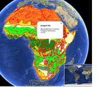
Environment Fund as part of the Carbon Benefits Project. Kindt and his colleagues modified vegetation maps drawn
up in 1983 by Frank White, an English botanist. These
were based on maps made by botanists in earlier decades.
"We have turned White's map into a tool for selecting
useful species, using an overlay on Google Earth," says
Kindt. "It is interactive and easy to use. You click on the
location you're interested in, and it provides information
about the vegetation type, with links to species composition
tables." Users can also select a subset of species to
provide desired end-products or environmental services,
and there are links to detailed descriptions of each tree
species.
Inevitably, the resolution for the map of Africa – White
used the scale of one to 5 000 000 – is lower than that
used for the VECEA project. "Eventually, we would like
to produce a map for the entire African continent which
provides similar levels of detail and accuracy as VECEA," says Lilleso. "Nevertheless, the maps are still accurate
enough to provide users with the sort of information they
need to decide which agroforestry species will grow best
in particular areas, and where to get their seeds and
seedlings." |