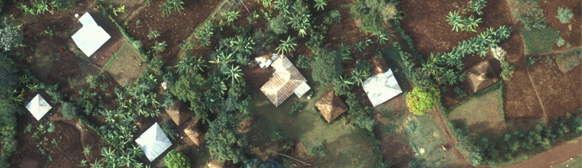
A World Agroforestry Centre study used remote sensing data to analyse the extent of tree cover on agricultural land, and its relationship with population density and climate. Over 1 billion hectares of agricultural land – or 43% – have more than 10% tree cover, and these areas are home to almost a third of the 1.8 billion people who live on agricultural land. Some 0.6 billion hectares of agricultural land have more than 20% tree cover, and 160 million hectares more than 50%. "Before we conducted the study, the only figures available were guesstimates,” explains Richard Coe, co-author of Trees on Farm: Analysis of Global Extent and Geographical Patterns of Agroforestry. These varied wildly, with one as low as 50,000 hectares and another of over 307 million hectares, the latter figure being based on the assumption that 20% of agricultural land is covered with trees. "There are limitations to our study,” continues Coe, "but it is a significant step in the right direction.”
Agroforestry is a feature of agriculture landscapes throughout the world, but the extent to which it is practised varies from region to region. It is particularly significant in Central America; less so in East Asia. There is a strong positive correlation between tree cover and humidity, but the relationship between tree cover and population density is less clear. This is presumably because other factors, such as markets, government policies, development programmes and local history, also influence the level of tree cover on farmland. The study has several limitations. For example, tree cover estimates are based on computer analysis of remote sensing of one kilometre square pixels. Fifty per cent tree cover in a square kilometer could mean one large block of trees – in other words, a small forest – or an even scattering across farmland. And the analysis provides no information about the nature and use of trees on farmland.
The global figures for tree cover are almost certainly conservative. There are large areas of agroforestry that are excluded from agricultural land, such as the jungle rubber systems in Indonesia and cocoa agroforestry in West Africa. In global land cover databases these areas are usually classified as forest, not as agricultural land. Trees on Farm contains some important messages for politicians, climate-change negotiators, development specialists and others in a position to influence policy. It provides firm evidence that large areas of agricultural land contain significant tree cover; it also suggests that certain areas – for example, along the fringes of the Sahara desert – could support many more trees on farms than they currently do. "What is needed now is a series of much more detailed analyses that provide a better understanding of where people plant trees, why they keep them and how they use them,” says Coe. Recent research conducted by the World Agroforestry Centre in India (see box) and Indonesia is beginning to do precisely that. |