Citation: Zomer, R.J., Bossio, D.A., Trabucco, A., Noordwijk, M., Xu, J. 2022. Global carbon sequestration potential of agroforestry and increased tree cover on agricultural land. Circular Agricultural Systems 2: 3 https://doi.org/10.48130/CAS-2022-0003
Abstract
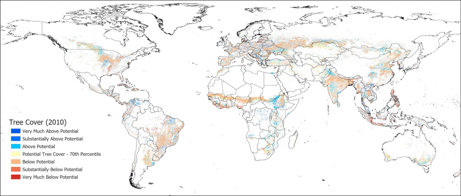
Biomass is fundamental to circular agricultural systems. Estimates of above- and below-ground biomass on agricultural land based upon IPCC Tier 1 estimates are compared with an updated carbon density map based on remote sensing, with results indicating the methodology and initial estimations are robust. Two scenarios are evaluated to estimate carbon sequestration potential of increasing tree cover on agricultural land: 1) incremental change and 2) systematic change to agroforestry. Estimates of above- and below ground biomass carbon were combined with a tree cover analysis to estimate the increase in biomass. Global increases (4−6 Pg C for incremental change; 12−19 Pg C for systematic change) highlight substantial mitigation potential. Increasing global tree cover on agricultural land by 10% would sequester more than 18 Pg C. South America has the highest potential, followed by Southeast Asia, West and Central Africa, and North America. Brazil, Indonesia, Philippines, India, the United States and China are among the top countries.
Trees on Agricultural Land: Food Security, Adaptation, and Mitigation
Increased use of trees in agriculture can lead the way towards a transformation of the global food system, with reslults from this new study showing that even minimal and incremental increases in global tree cover on agricultural land could provide short-term respite to carbon accumulation in the atmosphere, benefiting the livelihoods of small farmers, biodiversity, ecosystems, and ecosystem services around the globe.
The Global Tree Cover and Biomass Carbon on Agricultural Land analysis is part of on-going research focused on Trees on Agricultural Land: Food Security, Adaptation, and Mitigation, at the Center for Mountain Futures, a joint laboratory of the Kunming Institute of Botany (Chinese Academy of Sciences) and the World Agroforestry Centre (CIFOR-ICRAF). Building on more than a decade of work to quantify the extent, geographic distribution, and carbon mitigation potential of agroforestry, this study estimates the extent and distribution of trees and biomass carbon on agricultural land, and then asks the question: How much carbon would be sequestered if tree cover increased.
The research, and the various geospatial analyses presented here, are a product primarily of research conducted by Dr. Robert Zomer at the Center for Mountain Futures, in collaboration with Dr. Antonio Trabucco, Euro-Mediterranean Center on Climate Change. Writing and further research input and support for this paper included collaboration with Dr. Jianchu Xu, Director of the Center for Mountain Futures, Dr. Meine van Noordwijk, at the World Agroforestry Centre (CIFOR-ICRAF), and Dr. Deborah Bossio at The Nature Conservancy.
This international study is the outcome of a multi-year collaboration first started in 2008, and a follow up to a previous well received and highly paper on the topic of biomass carbon on agricultural land:
Global Tree Cover and Biomass Carbon on Agricultural Land The contribution of agroforestry to global and national carbon budgets
Zomer, R.J., Neufeldt, H., Xu, J., Ahrends, A., Bossio, D.A., Trabucco, A., van Noordwijk, M., Wang, M., 2016. Global Tree Cover and Biomass Carbon on Agricultural Land: The contribution of agroforestry to global and national carbon budgets. Scientific Reports 6, 29987; doi: 10.1038/srep29987

This previous study made an initial attempt to geospatially model and quantify the above- and below-ground biomass carbon on agricultural land using MODIS remote sensing data and IPCC Tier 1 carbon density estimates based on the Ruesch and Gibbs “IPCC Tier-1 Global Biomass Carbon Map for the Year 2000.
In this current paper, we compare and update the results of our previous analysis based with the recently released and improved "Biomass Carbon Density Maps for the Year 2010” (Spawn and Gibbs, 2020), providing an updated global, regional, and country-level analysis of biomass carbon on agricultural land. We then expand that analysis, based on the updated baseline and the previously used Tier 1 methodology, to look at the potential mitigation benefit of increasing tree cover within agricultural systems, in terms of above- and below-ground biomass carbon, under two landuse scenarios:
· The first scenario is an incremental change from current practices, i.e, increasing tree cover within the existing or a slightly modified agricultural system. For example, adding trees on the border of fields, along roadways and canals, or within conservation easements. These interventions increase tree cover within the agricultural landscape while not significantly changing existing agricultural practices.
· The second scenario evaluates the benefits associated with a more substantial shift to agroforestry systems and approaches which incorporate trees as a core component of the agricultural production system, either at the field level, or within agricultural landscapes more generally.
In each case, scenarios are developed based on the existing distribution of tree cover on agricultural land within ecologically reasonable bioclimatic strata.
Various Maps in jpeg format are also available for download from the Map Gallery.
An overview of methods and results are described in the following set of publications:
Citation: Zomer, R.J., Bossio, D.A., Trabucco, A., Noordwijk, M., Xu, J. 2022. Global carbon sequestration potential of agroforestry and increased tree cover on agricultural land. Circular Agricultural Systems 2: 3 https://doi.org/10.48130/CAS-2022-0003
Zomer, R.J., Neufeldt, H., Xu, J., Ahrends, A., Bossio, D.A., Trabucco, A., van Noordwijk, M., Wang, M. 2016. Global Tree Cover and Biomass Carbon on Agricultural Land: The contribution of agroforestry to global and national carbon budgets. Scientific Reports 6, 29987; doi: 10.1038/srep29987.
Zomer RJ, Trabucco A, Coe R and Place F. 2009. Trees on Farm: Analysis of Global Extent and Geographical Patterns of Agroforestry. ICRAF Working Paper no. 89. Nairobi, Kenya: World Agroforestry Centre http://www.worldagroforestry.org/downloads/Publications/PDFs/WP16263.PDF
Zomer, R.J., Trabucco, A., Coe, R., Place, F., van Noordwijk, M., Xu, J., 2014. Trees on farms: an update and reanalysis of agroforestry's global extent and socio-ecological characteristics. Working Paper 179. World Agroforestry Center, Bogor, Indonesia. doi:10.5716/ WP14064.PDF http://www.worldagroforestry.org/sites/default/files/WP89_text_only.pdf
Credits:
Research partly supported by the National Key Basic Research Program of China (Grant No. 2014CB954100), and National Science Foundation China (Grant No. 31270524). Additional support was also provided from the CGIAR Research Programs on Forests, Trees and Agroforestry and Climate Change, Agriculture, and Food Security. We also express our gratitude to the Carbon Dioxide Information Analysis Center (CDIAC), Oakridge National Laboratory and the authors of the 'New IPCC Tier 1 Global Biomass Carbon Map' and the 'Global Aboveground and Belowground Biomass Carbon Density Maps for the Year 2010' for providing the valuable online data used in this analysis. Also we express our gratitude to the authors of the MOD 44B MODIS Vegetation Continuous Fields datasets, and to the Global Land Cover 2000 Database, and the GADM for providing easy access online to the publically available global datasets used in this analysis, listed below:
Spawn SA, Gibbs HK. 2020. Global Aboveground and Belowground Biomass Carbon Density Maps for the Year 2010. ORNL DAAC, Tennessee, USA. https://doi.org/10.3334/ORNLDAAC/1763
Spawn SA, Sullivan CC, Lark TJ, Gibbs HK. 2020. Harmonized global maps of above and belowground biomass carbon density in the year 2010. Sci. Data 2020(7): 112. https://doi.org/10.1038/s41597-020-0444-4
Ruesch, A. & Gibbs, H. K. New IPCC Tier-1 Global Biomass Carbon Map for the Year 2000. (Oak Ridge National Laboratory, Oak Ridge, Tennessee, U.S., 2008). Available online from the Carbon Dioxide Information Analysis Center http://cdiac.ornl.gov/epubs/ndp/global_carbon/carbon_documentation.html
Hansen, M. C., DeFries, R. S. & Townshend, J. Global Percent Tree Cover at a Spatial Resolution of 500 Meters: First Results of the MODIS Vegetation Continuous Fields Algorithm. Earth Interactions 7, 10, 1-15, (2003). http://glcf.umd.edu/data/vcf/
DiMiceli, C. M. et al. Annual Global Automated MODIS Vegetation Continuous Fields (MOD44B) at 250 m Spatial Resolution for Data Years Beginning Day 65, 2000 to 2010, Collection 5, Percent Tree Cover. (University of Maryland, College Park, MD, USA., 2011) http://glcf.umd.edu/data/vcf/
Bartholomé, E. & Belward, A. S. GLC2000: a new approach to global land cover mapping from Earth observation data. International Journal of Remote Sensing 26, 1959–1977 (2005). doi:10.1080/01431160412331291297 http://www.un-spider.org/links-and-resources/data-sources/land-cover-map-glc2000-jrc
GADM. 2018. GADM: Global Administrative Areas Database v 3.4. GADM. http://www.gadm.org
The Centre for Mountain Futures (CMF/KIB) is an applied research laboratory jointly managed by the Kunming Institute of Botany (CAS) and the World Agroforestry Centre (CIFOR-ICRAF). Research is focused on mountain ecosystems, biodiversity, traditional communities, and development pressures impacting natural and cultural resources.